

Isaac’s Tea “Trial”
Isaac’s Tea Trail is a well established, way-marked, hiking route in Northumberland and Cumbria. With the exception of an out-and-back extension to Allenheads it traces the sales round of Allendale’s “local boy made good”, Isaac Holden (1805-1857), a 19th-century lead miner, tea-seller and eventual philanthropist and benefactor in the dale. The trail today comprises a 37-mile, hilly circuit over the fells and through the dales of the North Pennines starting and finishing in Allendale Town, Northumberland going via Nenthead (England’s highest village) and Alston – England’s joint-highest market town – both of which are in Cumbria.
While it’s possible to complete it as a continuous effort in a single day – running or even walking – I decided to take a more comfortable approach and do it as a two-man, supported relay. To avoid confusion with the trail itself, which has its own website, I decided to rebrand my version as Isaac’s Tea “Trial”. Clever eh?
Route map for Isaac’s Tea Trail by Durham Cow on plotaroute.com
Stats at a Glance
Distance 37 miles/60 km | Height Gain 4944 ft/1507 m | Maximum Elevation 582 m/1909 ft (The Dod/Black Hill nr. Coalcleugh) | Number of Sections 8 | Average Distance per Section 4.6 miles/7.5 km | Longest Section Section 8 (6.2 miles/10 km) | Shortest Section Sections 5 & 7 (4.1 miles/6.6 km) | Start & Finish Allendale Town Bridge, Allendale NY 835557 (what3words: reserving.contracts.derailed) | GPS FILE (COMPLETE ROUTE)
More photographs are available in our Google Gallery
Watch our video of ‘Isaac’s Tea Trial’ on YouTube
The Challenge
I’d walked Isaac’s Tea Trail in 2020 with my wife, Diane, and enjoyed it very much due in no small way to Allendale’s unique history. In addition to its many associations with the medieval “Border Reivers” it was also prominent in the lead-mining industry of the 19th century. Physical reminders from both periods proliferate throughout the length of East and West Allendale. The fact that there’s a not-too-extreme, way-marked trail visiting or passing close to many of these sites – in top-tier terrain – is the icing on the cake.
Having spent the previous year focusing on cycling and so losing a lot of running fitness, I’d decided that this year I’d try to halt the decline. I’d long held the idea that the trail might make a reasonable ultra-challenge as I know there’s been at least one race on it (which might still be the case). With progress having gone better than I could have hoped for thus far, I felt I might be pushing my luck, injury-wise, if I tried to do the route solo but if I split it into a two-man relay I should manage comfortably enough.
The most obvious candidate for a running partner was my 32-year-old son, Niall, who’s been training well for his umpteenth Great North Run in September. He seemed ridiculously keen when I put it to him and we quickly agreed that we’d have a go on Sunday, 15th July 2025, not realising at the time that it would be Father’s Day. Supporting us would be Diane, who I had no doubt would want to be involved but whose enthusiastic response was much appreciated. As both Niall and I had been training consistently we had the makings of a good day out assuming the weather was reasonably kind.
The Route
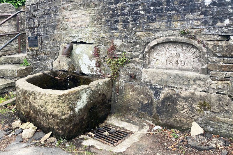
I hadn’t been aware, but could probably have guessed, that such a trail might have a “traditional” start/finish. In the Tea Trail’s case it’s the stone-troughed fountain dedicated to Isaac (who’d personally raised the money to pay for it) at the side of the main road, across from the market place, in Allendale Town itself. In blissful ignorance I decided we’d start and finish much more directly, on the Town Bridge, over the River East Allen, a short distance downhill from the market place, on what’s known as “The Peth”.
It can be done in either direction, clockwise or anticlockwise, though on both occasions I’ve plumped for the former and is the direction in which I’ve recorded it here. The entire trail, in both counties, benefits from well-maintained infrastructure (gates, stiles, steps and bridges) so you’re forever opening, closing, climbing and crossing stuff in the fields and gullies encountered. Each section has its own particular characteristics but I’d say the first section is particularly “busy”. Sections 1 and 2 involve nine miles of gradual ascent becoming increasingly remote as the trail crosses into Cumbria. The highest point (582 m/1909 ft) is on the watershed beyond Coalcleugh (Section 3).
Leaving behind the potentially boggy, exposed moor the route descends to the Quaker-built lead mining village of Nenthead which I want to say is in “Nentdale” though it appears that no such dale exists despite the River Nent running exclusively through what would definitely amount to a “dale” in my book. Together with Buxton, in Derbyshire, Alston claims to be England’s highest market town and – more interestingly I think – served as the inspiration for Royston Vasey, the town in which the UK comedy series The League of Gentlemen takes place. It’s an important hub on the busy A689 and A686 and its steep, cobbled market place has become familiar to many types of traveller over several centuries. It stands above the River South Tyne, not too far away from the source, in the Cumbrian part of South Tynedale.
A mile or so outside Alston – sharing the trail with Alfred Wainwright’s “A Pennine Journey” – the route crosses the A689, heading upwards onto the fells. Shortly after crossing the Gilderdale Burn, back into Northumberland, you’ll reach Whitley Castle (the Roman fort of Epiacum) whose enigmatic but well interpreted ditches lie on the Maiden Way, a 20-mile link road built by the Romans between the forts at Bravoniacum (Kirkby Thore) near Penrith and Magnis (Carvoran) on Hadrian’s Wall.
From there the route descends back to the A689, crossing in quick succession, the River Tyne Trail, the South Tynedale Railway and the River South Tyne itself. After following the South Tyne upstream, back towards Alston, the route leaves the gently undulating, well-surfaced lane, in favour of a steep, grassy, ascent to the tiny village of Ayle. After a short section along a lane, it then loses the height recently gained to cross the Ayle Burn, the boundary by which you return to Cumbria.
Here begins a long ascent, past Clarghyll Hall and, later, the redundant machinery of a former drift coal-mine, to a rugged track heading ever upwards to cross the A686, followed by an exposed fell where you return to Northumberland and West Allendale. The long descent on the track back into the dale is no less rugged. Once you’ve reached the road before Keirsleywell Row the going is much easier on a mix of road and trail as you eventually fall in beside the Mohope Burn.
Approaching Ninebanks there’s another steep climb away from the River West Allen, past Isaac’s Hearse House and St Michael’s church to reach Pasturehead. At Far Dryburn there’s a steep, grassy descent to the bridge over Dry Burn followed the another climb to reach the track onto Leadgate Bank. This marked the beginning of our final (6-mile) section which, after descending steeply over fields, undulates gently – eventually on a wooded track – for a final pull up, after the farm at Monk Farm, to Keenley Thorn from where the final three miles or so are ALMOST all downhill or at least gently undulating.
After a stretch on the road, the route turns left downhill, past Keenley Methodist Chapel, descending all the way to the River East Allen which it follows upstream on the floodplain before a couple of short, steep undulations approaching Allen Smelt Mill and the bridge over the River East Allen. On the other side of the bridge, the sometimes rugged riverside trail takes you back, past the Blackett Level portal, to Allendale Town Bridge from whence you started. Watch out for the final, short sting-in-the-tail ascent to The Peth. If your start/finish is Isaac’s Well then the “sting-in-the-tail” is going to be a little bit longer, to reach the market place. Don’t forget to say “hi” to the dalek as you pass!
Sections 1, 2, 6, 7 and 8 are entirely within Northumberland while Section 4 (Nenthall to Harbut Law) is the only section entirely within Cumbria.
For more cycling and walking routes, visit the Durham Cow on Plotaroute.
Section by Section
I’ve graded the sections “easy”, “moderate” and “challenge” based on my own perception of distance, elevation (length and gradient), terrain and exposure. It’s hopelessly subjective of course – a bit of fun really – though it might help some. “Easy” should be able to be managed comfortably by most runners (or walkers) given sufficient time. “Moderate” means that you’ll need to look at the distance and profile and make your own decision (distances have purposely been kept fairly short). “Challenge” is my way of saying that it’s NOT A ROAD RUN and needs to be treated with respect for one or more of the characteristics discussed. The more observant will have noticed that there are no “easy” sections however. If you think that what I’ve graded as “moderate” or “challenge” is “easy” that can only be a good thing.
Section 1: Allendale Town Bridge to Black Way, Knock Shield | 6.9 km/4.3 miles | 202 m/663′ | Moderate | GPS FILE
Going clockwise, the first section heads south, generally following the River East Allen upstream and so climbing gradually – mainly on trails. I give it a “moderate” grading because, although there are some sharp “ups and downs” they’re never too long, or extreme. Importantly, it’s sheltered and that’s always worth a tick in my book. The pastoral nature of the trail this far down in the dale means that there’s a lot of infrastructure to contend with (stiles and gates principally) meaning that speed will suffer. Simple, drop-latches seemed to be the norm so you can generally anticipate what you need to do to open the gate – particularly if the gear’s on the reverse side. There are quite a few streams to be crossed, always via a bridge, and usually with well maintained steps to assist. Spring this year, has been fairly dry, as was the trail which is quite likely to be a good deal muddier in wet weather. I really enjoyed this leg which I knew included Rowantree Stob, a ruined post-medieval “bastle” house in an idyllic location which I’ve visited on several occasions. Even with GPS I had a couple of minor navigational errors. Time for the section was 58 mins.
Section 2: Black Way, Knock Shield to Coalcleugh | 7 km/4.3 miles | 263 m/863′ | Challenge | GPS FILE
This was the first of Niall’s sections so I can’t give a first hand opinion on the day but I have walked and run it before. A good three-quarters of it is uphill, on a steady gradient but changeable surface, with everything from asphalt to moorland bog. There’s a slight dip after the ridge, then a short ascent on the road to reach the changeover at Coalcleugh. I’ve graded the section as a “challenge” because it has all the elements that matter – uphill profile, high elevation, rugged terrain and extreme exposure. The weather, for us, was “changeable”: warm sunshine, slightly humid in the dale, positively chilly on the tops, influenced significantly by a strong wind that was in our faces in the first half and thereafter on our backs. The forecast rain arrived in the afternoon though it rarely amounted to more than windblown drizzle.
Section 3: Coalcleugh to Nenthall | 7.5 km/4.7 miles | 122 m/367′ | Challenge | GPS FILE
At only 4.7 miles this would be my longest section and apart from a relatively short climb over the highest point of the course, and a little “stinger” near the former site of Brownley Hill Mine, after Nenthead, it was nearly all downhill. I’ve still graded it as a “challenge” however, due to the terrain and exposure in the first couple of miles. I should also consider navigation which, for me, went a little awry on the descent to the abandoned farm buildings at Roughside. Instead of passing above them, then turning sharply left to come back alongside – as directed by the way-markers – I took a more direct line towards them, approaching from the opposite direction. I realised quite quickly that something was wrong but wasn’t sure what exactly so I ran around the buildings, then directly to the gate where I knew I needed to be (I probably cut less than a hundred metres). Apart from the pleasure of running over fells, the main feature of this leg, for me, is the model village in Nenthead. Noticing it as you run past isn’t enough; even stopping to have a proper look is less than it deserves. You really need to spend some time there. We called in a couple of years ago and we both agree that the owner – who asks for donations to the air ambulance – is a creative genius!
Section 4: Nenthall to Harbut Law | 8.5 km/5.3 miles | 93 m/305′ | Moderate | GPS FILE
This was the second of Niall’s sections, one I’ve graded as “moderate” as it’s a relatively low-lying, undulating route, passing directly through the market place in Alston. It’s generally downhill, the only steep gradients being descents. It’s also fairly sheltered, following the River Nent on trails, tracks and roads through pastoral terrain. Despite the route being fairly straightforward he’d suffered a couple of navigational issues as a result of not paying sufficient attention to the GPS (of which I was also guilty). Nevertheless, he was happy to confirm that, like the rest of the trail, the route is clearly way-marked. The second occasion was after leaving Alston, following the River South Tyne downstream (in conjunction with the aforementioned ” A Pennine Journey” trail). He took an earlier track, uphill to the left, towards Mark Close (it’s not on the GPS route) with the result that he emerged onto the A689 earlier than he otherwise would have, approaching us from behind. And here’s me thinking I’d parked in the optimum position at the finish, right opposite the trail, where I was planning to get a couple of photographs of him running up the track towards us. Features on this section (as far as I’m concerned anyway) include the farmhouse at Blagill which incorporates a bastle and the many aspects and hospitality of Alston.
Section 5: Harbut Law to Ayle | 6.7 km/4.1 miles | 222 m/728′ | Challenge | GPS FILE
Graded “challenge” because it’s quite hilly and partially exposed. It continues to share the trail with ” A Pennine Journey” passing from Cumbria, into Northumberland via the footbridge over the Gilderdale Burh before reaching the Roman fort of Epiacum, which you can learn all about from the interpretation boards on the trail (downhill, on the other side of the site, there’s a farm shop and cafe). Next comes a long downhill section to Kirkhaugh footbridge across the River South Tyne via Castle Nook Farm (where Isaac’s future wife, Ann Telfer, was a domestic servant), the River Tyne Trail and the South Tynedale Railway. Eventually it joins a well-surfaced lane close to the Church of the Holy Paraclete at Kirkhaugh (where Ann and Isaac were married) and the farm at Underbank, another bastle site. Further along the lane, just after the route turns over the fields to Ayle, is Randalholme, a medieval tower house. I’m still not sure where I went wrong but I had a minor navigational error right at the end, as I was approaching Ayle. I headed directly for the main gate out of the field while it appears that the actual route goes through a gate in the wall on the right. In fairness to me, some maps show it as going the way I went but I’ve altered the GPS file to reflect the situation on the ground. Be aware that the lane through Ayle is tiny and that parking is very limited.
Section 6: Ayle to Keirsleywell Row | 7 km/4.4 miles | 217 m/712′ | Challenge | GPS FILE
This section is basically “down-up-down” on rugged surfaces for much of the distance hence its “challenge” grading. It’s nice on a nice day but could be much less so on a nasty one and you should go equipped with decent rain-gear for the exposed part over Ouston Fell/Mohope Moor, extending for a long downhill stretch to the isolated finish at Keirsleywell Row. It crosses from the South Tyne Valley to West Allendale both of which are in Northumberland but has to pass through Cumbria, for a final time, to get there – it’s relatively straightforward navigationally though. Clarghyll Hall is the major feature on the route.
Section 7: Keirsleywell Row to Leadgate Bank | 6.6 km/4.1 miles | 148 m/486′ | Challenge | GPS FILE
Despite being one of the shortest sections I’ve graded it as a “challenge” because the second half involves a steep climb followed by an even steeper descent to a stone footbridge over a burn at the bottom of a deep gully – with a subsequent climb back out. It’s one of the shortest sections however (even if only by degree) but offers little protection from the elements on the higher part in the second half. Features include Greenbanks YHA (obviously you’d need to book to stay there but it’s a great place), Isaac’s “Hearse House” a unique, tiny, and free museum that is always open (I think) and St Mark’s Church perched on the hillside nearby (it was in the first church on the site, consecrated in 1764, that Isaac was baptised). Not too far away, in the village of Ninebanks, is a medieval “pele tower” if (like me) you’re sufficiently interested.
Section 8: Leadgate Bank to Allendale Town Bridge | 6.2 miles/10 km | 192 m/630′ | Challenge | GPS FILE
I’ve graded this “challenge” based on its potential. If you’re doing the route in a single day, then fatigue might make it feel tougher than it would otherwise have been. It starts steeply downhill before undulating, fairly gently, on what, for the most part, becomes a sheltered, unsurfaced track, as far as the farm at Monk (another farm that incorporates a bastle, many features of which are visible from the trail). After that there’s a final, long pull uphill over fields to Keenley Thorns. Stepping onto the road means that much of what is left of the route is either downhill or relatively flat on the River East Allen’s floodplain. There are a couple of minor exceptions: the first being the approach Allen Smelt Mill and the second being what I referred to earlier as the “sting-in-the-tail”, the short ascent to reach Allendale Town Bridge or the slightly longer one to reach the market place. Unless you’re really tired neither should present much of an issue. Apart from the farm at Monk, look out for Keenley Methodist Chapel, Allen Smelt Mill (where there’s a cafe), the Blackett Level and the Sci-Fi museum on The Peth near the market place.