River Wear Trail & the Keel Crossing
Saturday 25th April 2026 | The objective of today’s walk was to have a belated first look at Sunderland’s Keel Crossing footbridge. The city’s newest bridge links Keel Square with the Stadium of Light football ground and could have an impact on route options for the Weardale Way in the months and years ahead.
To get there I’d been planning to use a familiar route involving the Weardale Way on the outward leg, returning via the railway path between South Hylton and Penshaw. However, on checking the map, it struck me for the very first time that the River Wear Trail runs along the north side of the river creating a perfect circuit. On the south side of the river, the RWT is essentially synonymous with the Weardale Way but it hadn’t occurred to me that it might have continued elsewhere.
This then, would be our hike for the day: we’d park in a familiar spot outside Mount Pleasant Park, cross the river via the nearby bridge at Fatfield and hike the RWT, past Washington Wetland Centre until, at North Hylton, we’d join the C2C cycle route and follow it all the way to our objective. We’d then return, as we have many times before, via the South Hylton-Penshaw railway path.
Stats at a Glance
Distance 23.6 km/14.7 miles | Elevation Gain 284 m/932 ft | Maximum Elevation 50 m/164 ft (European Way, Pallion) |Going Generally firm with potentially (very) muddy sections; track, trail, road, woodland, urban | Exposure Fairly sheltered | Navigation Various way-marking throughout (OS Explorer 308; Landranger 88)| Hospitality & Supplies Sunderland (All); Cox Green (PH; Ca) | Start & Finish Beatrice Terrace Riverside (Mount Pleasant) DH4 7PY; NZ 314540; W3W: ///translated.small.poetic | Grade Moderate | GPS File
On The Trail
We pulled up in Beatrice Terrance around 10 am, all in good time for a local 15-mile walk and struck out immediately, heading briefly upstream alongside a river where the high tide was just beginning to turn. Turning right after crossing the bridge was a new experience for me; it’s almost embarrassing to admit how excited I am to walk a new route, especially if it’s local. I’d brought along the GPS for navigation – just in case – but as I suspected, it proved to be unnecessary.
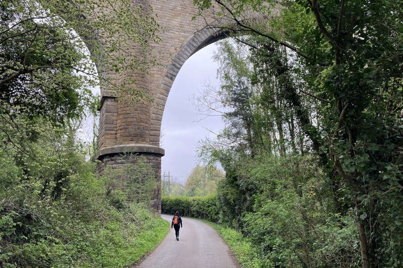
By the time we’d walked a mile on the metalled lane we’d already passed under the soaring Victoria Viaduct that was a critical part of the Durham Junction Railway when it opened in 1838. This was just in time to commemorate the coronation of the queen whose name it bears. Cox Green, a bit further on at 1.5 miles, offers the only pedestrian footway across the river before the Northern Spire bridge. It’s an important one, especially for villagers and recreational users, and figures in many walking and cycling routes in the area.
Washington Wetland Centre
Beyond Cox Green – around the 2-mile mark – we left the riverside to follow the mile-long boundary of Washington Wetland Centre. Our initial idea of keeping up a brisk pace which, for us, is around 3.5 miles per hour, was confounded by a familiar desire to stop and identify unfamiliar bird calls on the Merlin bird app. Although there were more species around the centre, the route elsewhere was hardly less lively.
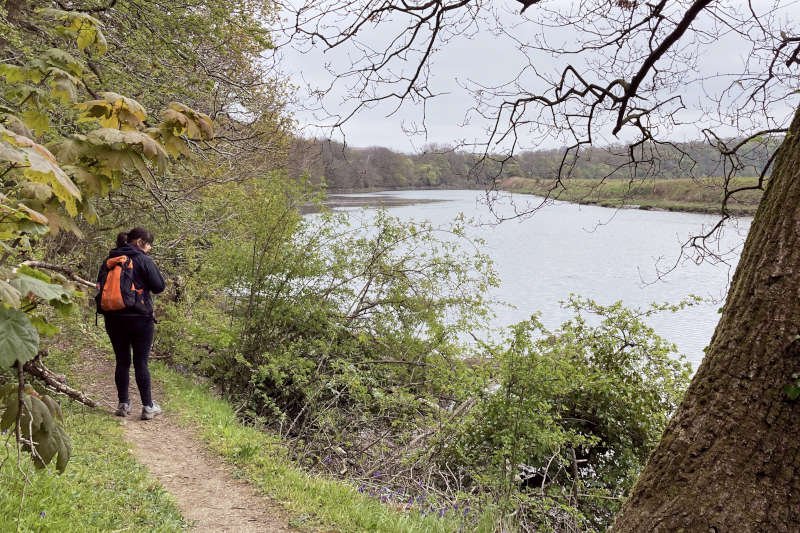
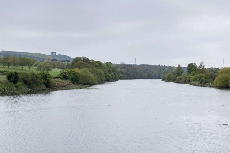
The part of the route between the Wetland Centre and North Hylton is a bit more rugged but benefits from decent infrastructure (bridges, steps and duck-boards). Our walk took place during a period of extended dry weather but, in wetter conditions, I fancy it could be a great deal muddier. After returning precipitously to the river at around 3 miles, I took the opportunity to grab a couple of pics of familiar Weardale Way locations from unfamiliar viewpoints: downriver across Offerton Haugh and, from the same spot, upriver with Penshaw Monument in the shot (you pass close to it on this section of the Weardale Way but can never actually see it).
North Hylton & The Stadium of Light
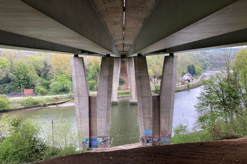
In order to tick off four miles it’s necessary to make a steep climb through High Wood where I must have overlooked a path (now added to the route as an option) that appears to lead directly back downhill, through the wood, to Ferryboat Lane and along the riverside to North Hylton. Instead, we continued on the higher route which has the advantage of a nice panorama from under the bridge, above Ferryboat Lane. From there, that trail too heads downhill, through the wood, to join the C2C (NCN 7) before descending a short distance further into North Hylton at around 4.5 miles.
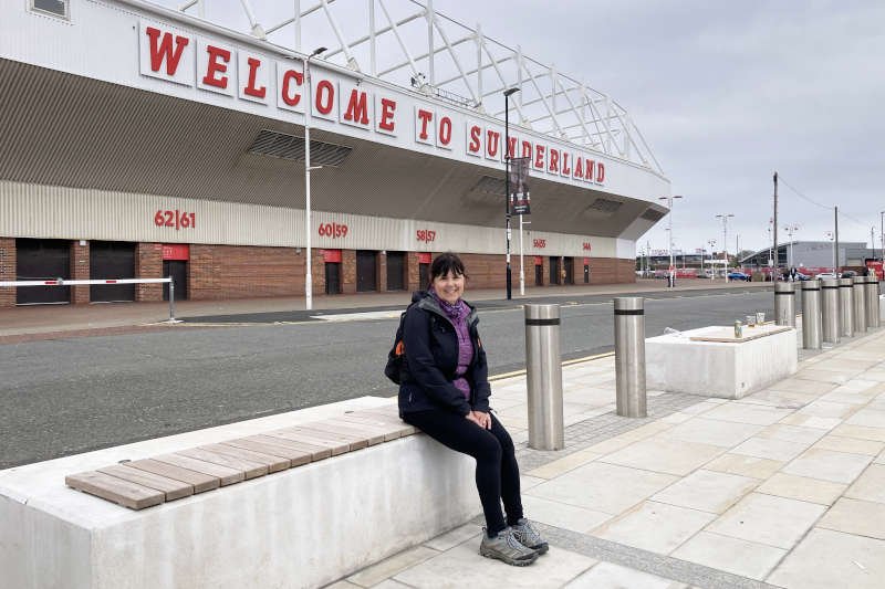
From North Hylton progress is swift, if a bit harsher, on metalled road and the C2C shared-use path. The route goes past the Northern Spire Bridge which, since 2018, is the tallest structure in Sunderland. Finally, you reach the Stadium of Light, Sunderland AFC’s football ground, opened 1997. The stadium stands on the site of Wearmouth Colliery which operated from 1834 until its closure in 1993. When it opened it was the deepest coal mine in the world and the last in the Durham coalfield to close.
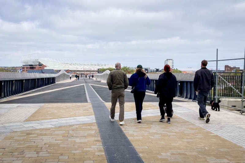
Keel Crossing & The Keel Line
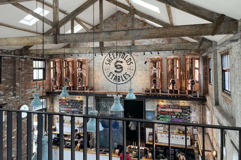
Not far away from the stadium is the Keel Crossing, incorporated into a scheme known as the Keel Line. It’s part of Sunderland’s grand regeneration plan to extend its previously declining city centre all the way up to the gates of the the football ground. On the north side of the crossing is the attractive Sheepfold Stables hospitality complex to which we repaired for a beer and a hot drink. While it has a great vibe, it’s quite busy so I’d probably be inclined to give it a miss on match day.
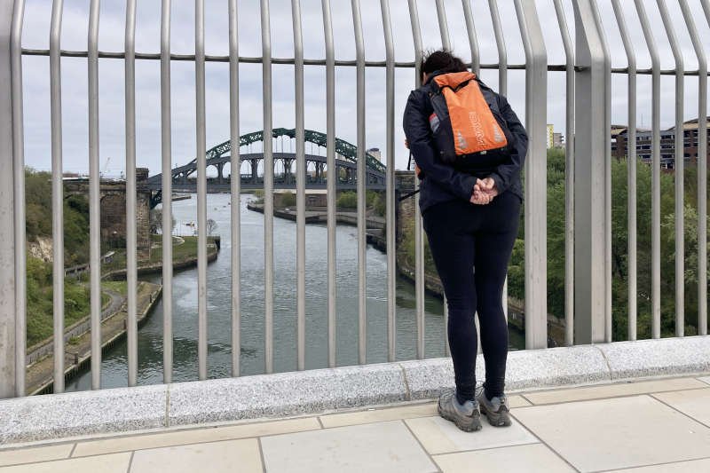
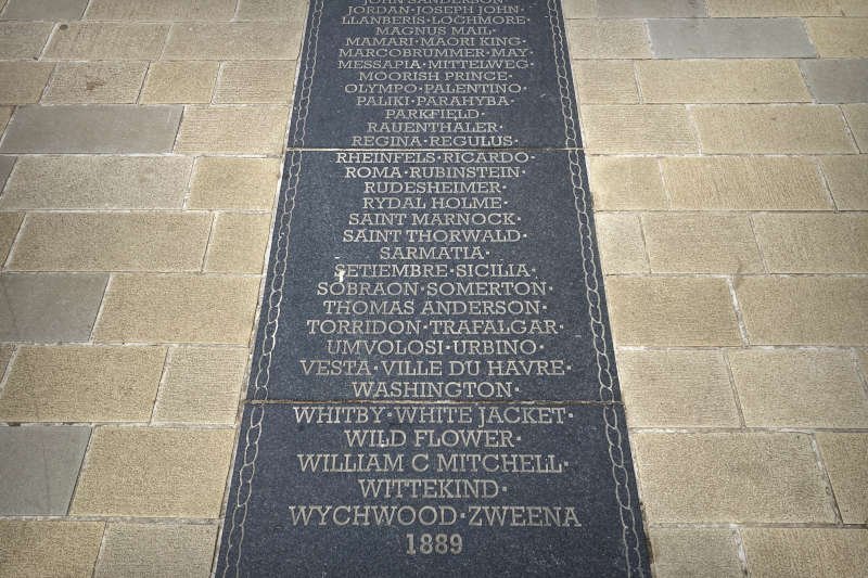
Apart from its utility and offering a new panorama on the Wearmouth Bridges, the crossing’s most notable feature (as far as I’m concerned) is the strip which runs down the centre of the bridge as far as Keel Square. It appears to catalogue what I think is all of the Sunderland shipyards over time as well as every ship they produced – we got as far as the 1880s but there was still quite a long way to go! A feature like this helps to comprehend how important building ships once was to the economy and character of Sunderland where the industry officially goes back to 1346. All in all, I think the crossing makes a practical, attractive and thoughtful contribution to the city – I hope that it proves to be a great investment.
Cox Green
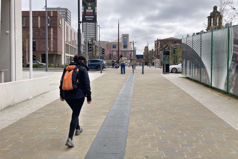
Taking our leave of the bridge, we headed upriver towards Millfield, past the site of the Vaux Brewery (another major employer in ship-building times) and the yet-to-be-completed Riverside Park. Here, at around the 9-mile mark, the route joins another shared-use path which follows the Tyne & Wear Metro line out of the city to its terminus at South Hylton, a distance of just over 2 miles.
At the Metro station we crossed the road to continue on the gravel railway path. This is the former Penshaw branch of the Durham & Sunderland/North Eastern Railway. Opened in 1852 it became defunct, like so many others, just over a century later but is now a popular recreational path passing close to Penshaw Monument. After a couple of miles we turned off the path to join the road downhill into Cox Green for another drink, this time at the Oddfellows Arms.
A Short Walk To The Finish
Just over a mile of the route – entirely alongside the river – remains. Still in the village we passed the footbridge mentioned previously and the Alice Well, Cox Green’s only source of fresh water before WWII. A bit further along, before passing back under the Victoria Viaduct, there are a couple of blocked tunnels that once linked sandstone quarries to riverside staithes from which keel-boats operated. Finally, if it’s a nice day, make sure you make a last minute detour into Mount Pleasant Park to visit the ornamental lake where there’s always a variety of seabirds and waterfowl.