

Haltwhistle Burn & Cawfields Quarry Hike
Monday 25th August 2025 | Now that we’ve finished reviewing the Weardale and Teesdale Way trails, I’m focusing on visiting places that have at least one special feature of interest. Last week’s was a Ray Lonsdale sculpture while this one will be the first of several geological sites taken from a newly acquired book titled Northumberland Rocks by Ian Jackson (Northern Heritage ISBN 9781916237674).
Because Diane had been having some issues with discomfort in the soles of her feet, I selected a site from the book that I thought would offer a relatively gentle, short walk that could easily be cut shorter if necessary. The entire route, which I’ve extended to include a section of Hadrian’s Wall, is way-marked and can be done as loop or figure-of-eight depending on preference (there’s also an optional detour).
In the book it’s listed simply as “Haltwhistle Burn” exploring familiar sedimentary sequences of the Stainmore Formation — it’s Carboniferous geology (300-360 million years) similar to that found in neighbouring Weardale. The route with which it’s associated is based on the popular Haltwhistle Burn Trail which explores former industrial sites in the attractive, wooded gorge through which the Haltwhistle Burn flows.
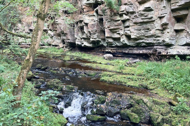
What surprised me was that as well as the typical mills, quarries and lime kilns I was expecting, it also includes colliery sites even though it’s well to the west of the highly productive Great North Coalfield. Along with other pits in the area, they mined seams in the vicinity of a layer of limestone known as the “Little Limestone”, not a major seam but clearly profitable enough to sustain a century of mining.
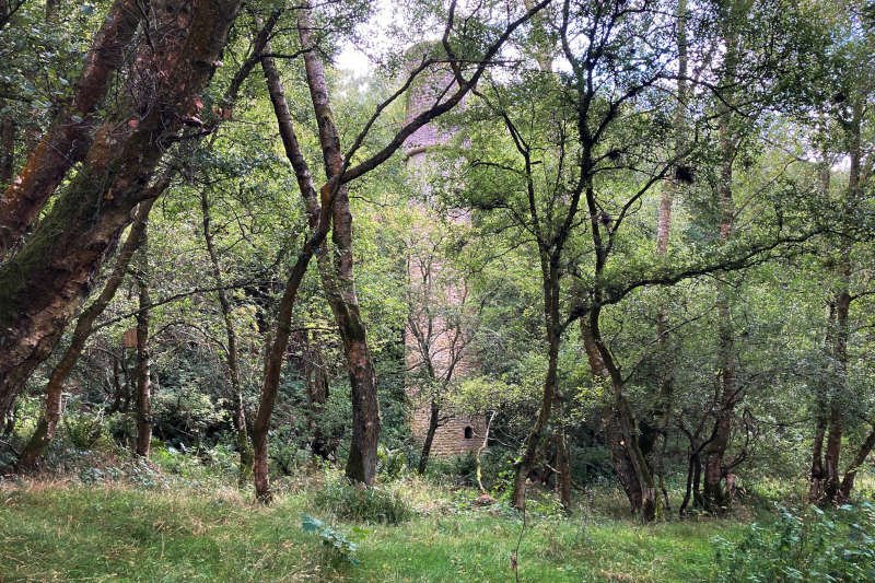
On a less esoteric note, you should find car-parking on the route at Fair Hill (near Sainsbury’s) or slightly further up the route, by Haltwhistle Jubilee football club (see the route description). Also, as is the case with many woodland trails, if you want to profit from the best views it’s often better to visit in late-autumn/winter/early-spring, before foliage obscures and/or darkens things (had it not been for some families looking at it, I might have even missed the Fell Chimney which is a bit of a claim given the size of it).
Stats at a Glance
Distance 9 km/5.6 miles | Elevation Gain 162 m/531 ft | Maximum Elevation 206 m/676 ft (Gt. Chesters/Aesica) | Going Generally firm with potentially muddy/wet sections; trail, road, track, farmland, woodland, urban | Exposure Very exposed on the highest parts; sheltered in town & woodland | Navigation Partly way-marked on FPs/BWs (OS Explorer OL43; Landranger 87)| Hospitality & Supplies Haltwhistle (All); The Milecastle Inn, B6318 (PH); Cawfields Quarry (kiosk) | Start & Finish Market Place, Haltwhistle, Northumberland NE49 0DD (what3words: ///lazy.decorator.cages) | Grade Moderate | GPS File
More photographs are available in our Google Gallery
On The Trail
Starting from the market square in the town centre, near the Manor House Inn, cross the road and go through an alley (Stonecroft). Bear left (L) across Sainsbury’s car-park, uphill on The Mart, L on Fair Hill, then right (R) on Willia Rd. Continue 250 m to the information point for the Haltwhistle Burn Trail (in the Burn Field village green car-park by the Haltwhistle Jubilee football club). From the information point, continue 200 m on Willia Rd and, assuming you’re following the figure-of-eight route (the loop version is hardly any different) cross the burn via the footbridge (FB) by the former brick/pipe works.
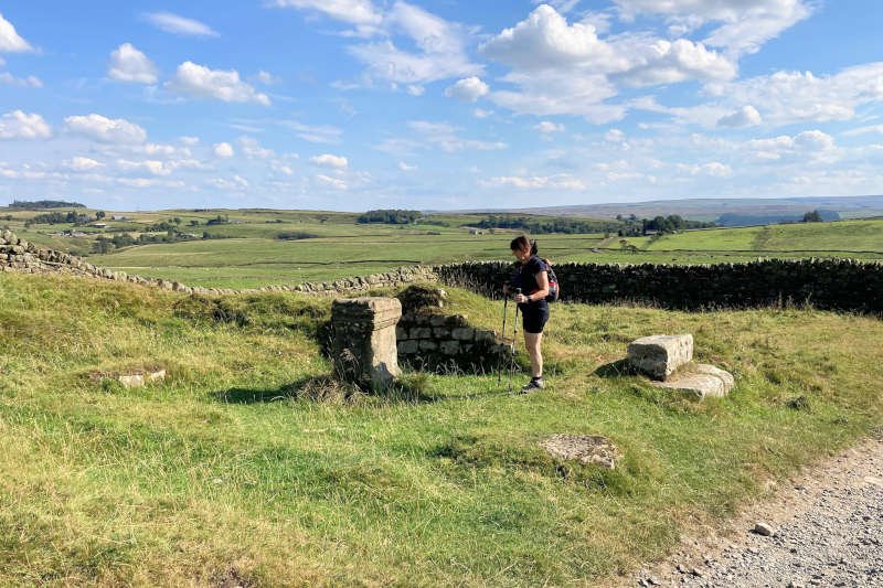
East End Pit & The Fell Chimney
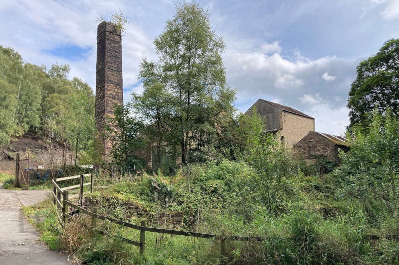
Turn L and continue ~600 m upstream, past the site of Low Mill, to another FB. Cross the bridge and turn R. Continue 1.3 km on the trail, past the site of the former East End Pit drift mine which operated before and during the 1840s. The site is marked by the “Fell Chimney” which, although fully intact, is somewhat shrouded by leaves at the height of summer.
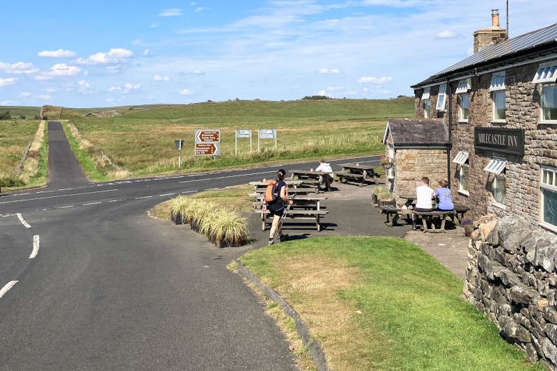
Continue on the trail, past a couple of lime kilns — yet again obscured by vegetation at the height of the season — to reach the busy B6318 (Military Road). Cross with care, to a narrow but well defined FP on the other side (it’s quite close to the road though). Continue 200 m to NEWBRIDGE FARM where there’s an optional detour. EITHER continue 250 m on the B6318 to the Milecastle Inn OR bear L, following the fingerpost, on the Haltwhistle Burn Trail alongside the wall (it’s overgrown in summer so try to avoid being nettled).
Haltwhistle: ‘Centre of Britain’
Not only is Haltwhistle the closest town to the Roman Wall, it also claims to be the geographical “Centre of Britain”. Until the end of the 13th-century, it was located within the medieval “Liberty of Tynedale”, then a part of Scotland. Deteriorating cross-border relations meant that by the 16th-century, residents had to construct homes that could withstand the depredations of armies as well as often murderous raids carried out by the notorious Border Reivers . Many fortified buildings from the period still exist in the town (marked by blue plaques). In much calmer times, over two centuries later, coal mining, of which the local South Tyne Colliery (1906-31) was an example, helped bring a degree of prosperity to the town. Today, the mines (and the work) have gone but a pleasant ambience remains along with good transport links and plenty of hospitality.
If you’ve opted for the pub then, when you leave it, the route heads directly up the minor road opposite — across the main road — heading for the unmistakable “shark-fin” land-form of Cawfields Crag. After leaving the road for the trail at the kissing-gate on the bend we had to walk through the middle of a herd of cattle with calves. They were completely chilled however, though it might have been different if we’d had a dog.
The Vallum
Continue over a compact series of low ridges running east-west. This is an enormous earthwork which the historian monk, Bede, first referred to a “vallum”; it’s about 35 m across and, apart from a gap between Wallsend and Newcastle, runs the entire length of the wall. It’s purpose is somewhat ambiguous but may have been a means of marking the limit of military influence (somewhat like barbed wire).
Milecastle 42
To the north of the vallum the symmetrically sloped footprint of Milecastle 42 on the Roman wall at Cawfields. It sits on the steeply pitching Whin Sill which you’ll find displayed to better effect on the face-side of the crag, overlooking the lake.
Cawfields
Cawfields was once a quarry from which the hard, igneous dolerite, that quarrymen called “whinstone”) was extracted from the Whin Sill for use as road stone. It also utilised the railway that ran past the industrial sites on the Haltwhistle Burn, to the main line at Town Foot and the River South Tyne. While most Whin Sill quarrying ceased there’s at least one active example near High Force, in Teesdale.
If your energy is in short supply but you think you’re up to tackling the steps to the top of the crag, take some time to appreciate the panorama northwards from the milecastle. An equally fine view across the lake awaits from the top of the crag and is definitely worth the effort. If you didn’t visit the pub (or even if you did) there’s often a mobile refreshments kiosk by the toilet complex at the other end of the quarry (I can’t promise but it’s always coincided with my visits).
After leaving the quarry, turn R, over the bridge (crossing the nascent Haltwhistle Burn), then immediately L, over the stile, following HADRIAN’S WALL PATH up the hill to the farm at Great Chesters. The shorter, more direct route, from Newbridge Farm continues on the Haltwhistle Burn Trail, from a kissing gate on the others side of the burn. It’s a distinct trail which looks like it could be quite muddy in extended wet/cold weather. Follow the burn upstream for 800 m to reach the road by the bridge mentioned above. You can, of course, easily visit the quarry from here.
Great Chesters (Aesica) & The Stanegate
Great Chesters is the highest point on the route and is built on the 3-acre site of the Roman fort of Aesica. Crossing the stile you’re entering by what, near enough, was the main gate or “Porta Praetoria” from the Military Way, which is still visible. The fort adjoined the wall on the south side and was built on the site of Milecastle 43. Turning L on the track, an offshoot of The Stanegate, referred to below, you leave via what was the fort’s south gate where you’ll find a stone altar on the site of one of the gatehouses.
Follow the track downhill, back towards the B6318. At the bottom of the hill, where the track joins the lane, you re-cross the vallum then, shortly after that — between Markham Cottage and the B6318 — you cross the main course of The Stanegate. The Stanegate was another important Roman communications route serving the wall. It’s still extant and even used in places though not at this location
Missing Footpaths & Bastles
Bear R across the road, to the bridleway (BW) on the other side. Continue south on the BW towards Lees Hall Farm. Through the main gate, follow the track through the farmyard then R around the back of the farm buildings. Although the map shows a FP downhill across a large field, on investigation it seems that the fully functional gate into the woods has been BLOCKED, seemingly on purpose, using newly planted thorn bushes. There are no notices but it might be the intention to encourage use of the track — which becomes Willia Rd — to get to several access points for the Haltwhistle Burn Trail.
While the road itself will take you directly back the way you came, you can also cross to the trail via any one of four FBs further down. Whichever way you arrive onto the trail (if, indeed, you choose to at all), to complete the loop, retrace the route past the brickworks. Continue 0.5 km and turn R on the trail, around the end of a single row of houses. Bear L through some allotment gardens then R along the back of Shepherd Terr. to the main road. Turn R, then immediately R again — steeply uphill on Castle Hill — and continue to the finish in the Market Place.
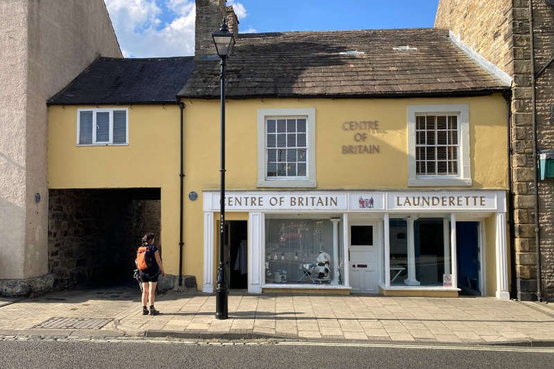
On the way you’ll pass various buildings that are, at least in part, fortified houses often referred to as ‘bastles’. They’re associated with the period of the Border Reivers which, at its height persisted through almost all of the 16th-century and into the 17th. Although there are more, the easiest to identify are those marked with blue plaques in the town centre, including the Centre of Britain Hotel and the adjacent launderette. An identifying feature is their massive stonework (at the base of the buildings, in the alley).
Once back in town, we slaked our thirst at the Manor House Inn, a former coaching inn, in the market place. Its more recent claim to fame is that it was a winner in Channel 4 TVs “Four in a Bed” competition. After a short, but very warm walk it was definitely a winner with us.