I probably wouldn’t have thought about putting this relatively gentle cycling route together if it wasn’t for its fascinating historical context explained below. Because there are lengthy urban sections however, it’s advisable to avoid rush hours and school runs. Living in Durham, I chose to start closest to home, on the south side of the route, at a spacious lay-by set back from the main road into Bedlington, close to Hartford Hall. The plan was to ride anticlockwise around the boundaries of what, up to the middle of the c19th, was known as Bedlingtonshire, once part of County Durham. I’d do this by crossing the River Blyth then riding east through the outskirts of Cramlington to the coast. I’d turn north on the NCN 1 (England Coast Path) and continue through Blyth to Newbiggin then west on the NCN 155 as far as Ashington. Although I could go all the way to Morpeth I was keen to visit the village of Bothal which meant cutting the corner but offered the advantage of good cycling through quiet, interesting lanes.
Distance 47 km/29 miles | Height Gain 327 m/1073 ft | Max Elevation 58 m/190 ft | Going Metalled roads, generally flat with infrequent, short but sharp gradients. The course of the River Wansbeck is deeply incised around Bothal requiring steep gradients and sharp turns. The route is often exposed but with multiple opportunities for shelter | Navigation Sustrans Cycle Map 34 (Tyne & Wear) | Other Routes NCN 1 (Coast & Castles South); NCN 115 | Supplies & Hospitality Blyth (All); Bedlington (All); Newbiggin-by-the-Sea (All); Ashington (All); [Morpeth (All)] | Start & Finish Lay-by off Hartford Rd (A1068) near Hartford Bridge, Bedlington NZ 244804 | Grade Moderate
If you start where I did the route will take you over the River Blyth, below the impressive Georgian frontage of Hartford Hall, within the first kilometre. After a short climb you’ll find yourself in the sprawling modern township of Cramlington, constrained on all sides by busy trunk roads. Because I’d opted not to use GPS there was nothing to alert me when I missed the turn onto an innocuous cycle path by Cramlington football club. The error compounded quickly and when I finally realised I was off-course it was difficult to make a U-turn in the heavy school-run traffic which I’ve already advised is best avoided.
What’s Special About Bedlingtonshire?
In the 10th century the tiny Northumberland village of Bedlington was purchased by Cutheard, Bishop of Lindisfarne between AD 899-915. In AD 995 the Lindisfarne monks arrived in Durham with the body of St Cuthbert. The lands they’d acquired – known as the ‘Patrimony of St Cuthbert’ – were incorporated into the Bishopric of Durham. This included ‘Bedlingtonshire’ – not only the village but the area between the Wansbeck and the Blyth, east of the parishes of Morpeth and Stannington. Being wholly outside the borders of its parent county it was an ‘exclave’ along with Norhamshire and Islandshire (also in Northumberland), and Howdenshire and Craikeshire in East Yorkshire. The situation persisted until 1844 when they returned to their respective counties. This was the arrangement the so-called ‘Prince Bishops’ inherited when Durham became a County Palatine in the c14th. Here the bishop was the ultimate authority – spiritual and secular – who ruled as a king on behalf of the king hence the mitre, coronet and helmet incorporated in the bishop’s crest (left).
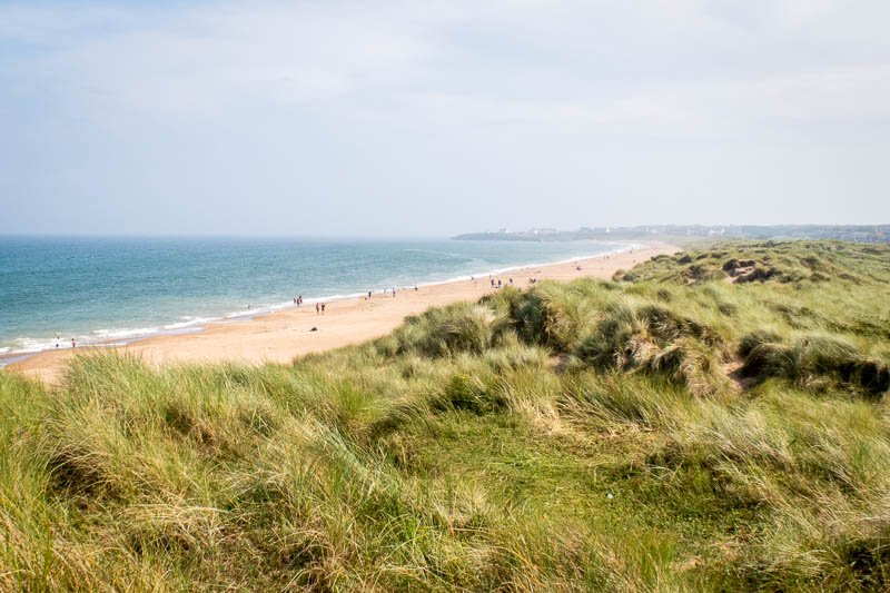
Once I found my way back onto the route my next issue was to decide on the relative merits of the road versus the cycle path. The concept of cycle routes is great but many of the cycle paths used, especially in urban areas, while being theoretically safer don’t exactly promote efficient cycling and are frequently less well maintained than the road. As usual, I eventually migrated permanently to the road and quickly found myself overlooking Blyth’s South Beach where the sands and dunes are as attractive as any in the country.
South Beach, Blyth, looking south to Seaton Sluice
In general, the terrain offered by south east Northumberland’s coastal plain is ideal for cycling: low hills in the heart of the Pennine Coal Measures geology that spawned the Great Northumberland coalfield. Coal has been mined here since the c13th – possibly earlier – and every town on the route has had one or more collieries associated with it, with many in between. The rivers have cut their own deep channels however, creating infrequent gradients which shouldn’t be underestimated – up or down.
Blyth
If you hang around on The Links at the coast for a coffee or an ice-cream you might notice the thrusting (replica) gun-muzzles of Blyth Battery nearby. The battery of guns was constructed during WWI as defence against attack from the sea exactly as happened – with devastating effect – at Hartlepool, Whitby and Scarborough in December 1914. Anti-aircraft guns, searchlights and barrage balloons were added during WWII to protect Blyth’s important industrial capacity from the much greater threat of air attack.
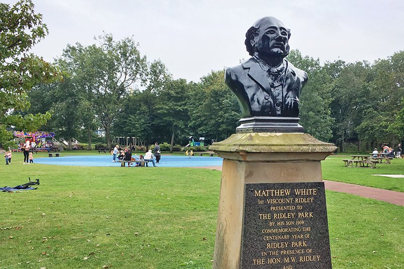
As far as I’m concerned Blyth is, and always will be, best known for being home to Blyth Spartans who, as non-league ‘giant killers’, made it to the fifth round of the 1977-78 FA Cup. The team have been at Croft Park for over a century playing today in the National League North. Ridley Park is where this trail leads however, a public park opened formally in July 1904 on land that had long been used by miners and their families for picnics. It’s still a pleasant area in which to enjoy refreshments from the coffee shop you’ll find there.
Ridley Park, Blyth
Down the adjacent back lane of Bath Terrace is an 18-metre high, white-painted lighthouse known as Blyth High Light. Built in three phases (10 m in 1788 ; +4 m in 1888; +4 m in 1900), it must surely have been one of the easiest lighthouses in the world to get to and continued in service until 1984. Not far away from the lighthouse and the park, moored on the quayside near the lifeboat station, is the ‘William II’, a 100 year-old tall ship known as a ‘ketch’. It’s similar to the original ‘William’ which was built at Blyth and on which Captain William Smith (also from Blyth) discovered The South Shetland Islands archipelago – located between Argentina and Antarctica – in 1819.
In the mid-1800s the river was dredged and staithes built so that coal could be delivered by rail to waiting ships. This introduced a long period of prosperity to the town reflected in the ethereally waving arms of Simon Packard’s 2002 sculpture titled ‘Spirit of the Staithes’ found today on the same quayside. Close up it seems wholly abstract but walk up Wellington St to the roundabout for another perspective. It’s quite clever (see the photo on the map to see what I mean).
‘Spirit of the Staithes’ (2002) by Simon Packard, Blyth quayside
A bit further upriver was the shipyard of Blyth Shipbuilding Company. Between 1811 and 1967 the company, in one guise or another, produced merchant vessels and warships including HMS Ark Royal, the first seaplane carrier (1914) and HMS Audacity* (1940). From 1911, at the same time as ships were being built on one side of the river they were being broken up on the other. Many vessels, including Russian submarines, ended their service at ‘Battleship Wharf’ where they were scrapped and recycled.
*HMS Audacity was a WWII ‘escort carrier’ which began life as the SS Hannover, a German merchant vessel. After being captured in 1940 she was eventually taken to Blyth for conversion. Her brief but busy active service concluded in December 1941 when she was sunk by torpedoes from U-751. One of the Fleet Air Arm pilots rescued from the Mediterranean the next day was Lt. Eric ‘Winkle’ Brown, soon to become Britain’s chief war-time test pilot and one of the world’s most distinguished aviators. He is credited with having flown 487 types of aircraft, a record that is unlikely to be surpassed. Nothing at all to do with the ride but I just had to find an excuse to put it out there.
Blyth’s harbour today is generally very quiet
Shortly after leaving the harbour you pass the looming, monolithic block that is the ‘Catapult’ building – the National Renewable Energy Centre – part of Blyth’s rebranding in the ‘sustainable energy’ sector. Before it was filled in during the 1890s you’d have been crossing a watercourse known as ‘The Slake’ or ‘The Gut’’ which separated the towns of Blyth and Cowpen. It’s Cowpen that the NCN1 now makes its way through, along Crawford Street which, although it’s relatively quiet, is in desperate need of resurfacing. Currently there’s building work going on (as there seems to be everywhere these days) and with any luck it might get it.
Just before joining the A193 the route turns right, heading directly for the bonny banks of the Blyth estuary, opposite the mouth of the Sleek Burn. Prior to 2003, you’d have been looking over the water at Blyth’s two power stations, each with a pair of tall chimneys which, for over 40 years, pinpointed the town in the landscape.
View over the River Blyth towards the site of the town’s former power stations
After a couple of kilometres of leisurely cycling upriver you reach Kitty Brewster Bridge* which has carried traffic over the River Blyth since 1960. When the A189 was converted to dual-carriageway in 1996, a second carriageway was added on the downstream side. The railway viaduct upstream – referred to interchangeably as Bebside or Bedlington Viaduct – was built to replace the original wooden bridge in 1930. Currently used for freight, it will help provide passenger services on the new Northumberland Line linking Ashington with Newcastle in 2024. *’Kitty Brewster’ is the name of the farm below the bridge whose neighbours for a while during WWII were German prisoners-of-war.
Bedlington
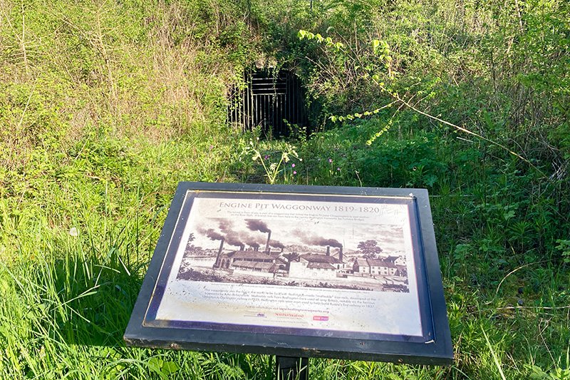
On emerging from under the railway viaduct there’s a short, steep climb quickly followed by an equivalent descent to Furnace Bridge, the means by which you cross the Blyth for the final time. The name of the bridge gives a clue to what would have been found here during most of the c18th. Bedlington Ironworks was established in 1736, initially manufacturing nails before switching to the patented malleable railway track which it supplied around the world. A century later, in 1837, the business began a short-lived venture in manufacturing locomotives, closing in 1852 despite producing some notable engines. The ironworks on the north side of the river didn’t last much longer and closed in 1867.
Tunnel entrance for the waggonway that served Bedlington Ironworks
Over the bridge, Furnace Bank provides another opportunity to get out of the saddle after which you take briefly to the trail again passing a tunnel entrance on the waggonway that closed with the ironworks. You continue an easy ascent to a part of Bedlington known as Bedlington Station. A long, reasonably flat, section on the road follows, re-crossing the A189, back to the coast, through East Sleekburn and Cambois.
Cambois
Although the name Cambois looks French, it’s more likely to have Gaelic or even Cumbric roots being pronounced ‘cammus’. Between 1862 to 1968, like so many other towns and villages in the North East, it boasted its own colliery. Apart from some repurposed buildings and a memorial pit-wheel (at least it’s a full one) there’s not much left to indicate that men ever worked below this lovely part of the coast. Pictured below is the view they’d have had when they started and finished their shift.
View over Cambois Bay and the Wansbeck Estuary to Newbiggin-by-the-Sea
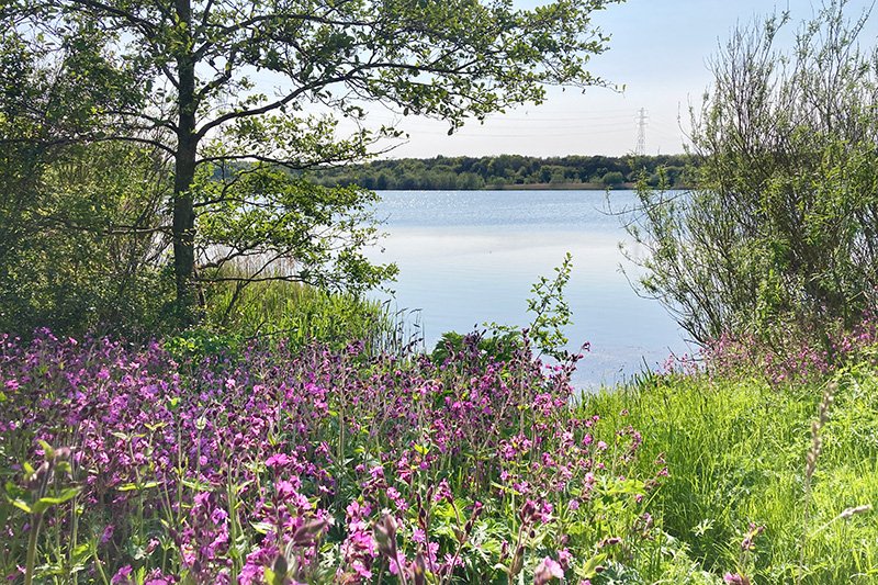
Next, the route turns inland again, to cross the Wansbeck (known locally as ‘the Wanney’) northward, on a cycle path running alongside the A189 over North Seaton Bridge. The barrage across the river to the west was built between 1974-75 to help create the 112 hectares of what is now Wansbeck Riverside Park. The rapidly approaching road junction at North Seaton is a bit of a nightmare: you can either cross the first two lanes as a pedestrian following the cycle route (there’s a tunnel to take you to the other side of the northern section of the A189) or get onto the road and do it that way but be warned, it’s big and busy at peak times.
Newbiggin-by-the-Sea
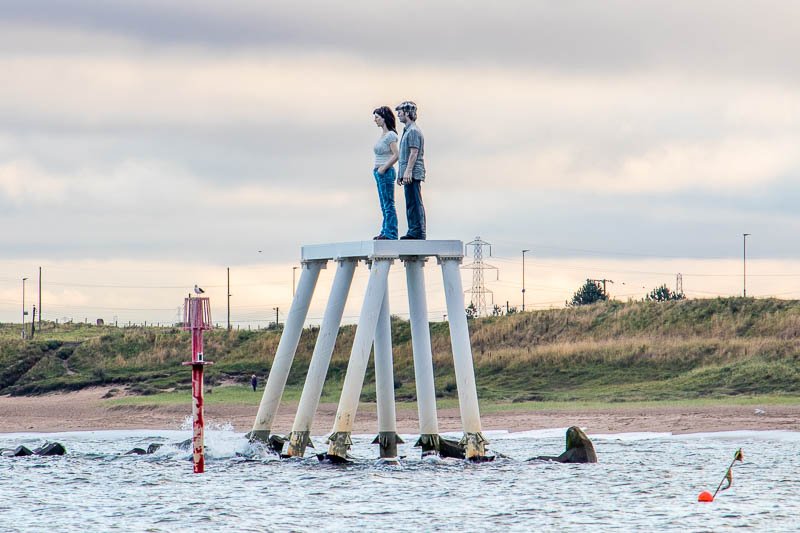
With the junction behind you it’s an easy ride into Newbiggin-by-the-Sea (there are many ‘Newbiggins’ in the North East, which simply means ‘new building(s)’). The town was a major port for shipping grain in the Middle Ages. Later, in the Victorian era, it was apparently Northumberland’s most popular resort. It still boasts a fantastic beach and promenade from where you can look seawards to contemplate Sean Henry’s intriguing bronze-and-steel sculpture ‘Couple’ (there’s a smaller version on shore). As much as I like it I’m far more drawn to old stuff like Newbiggin’s Grade I-listed c13th church of St Bartholomew on the headland overlooking the bay.
‘Couple’ (2007) by Sean Henry, Newbiggin-by-the-Sea
When you’re all done it’s a gentle ride out of town on the NCN 155 to cross the A189 yet again, into Ashington. To the north is Queen Elizabeth II Country Park developed in the 1980s on former spoil heaps from Woodhorn Colliery. The colliery itself is open to public as Woodhorn Mining Museum which I had the pleasure of visiting recently.
Ashington
Apart from its distinctive accent (which, with the closure of the pits may now be waning), Ashington is probably best known for its footballing families – the Charltons, Bobby (Man Utd) and Jackie (Leeds Utd) and the Milburns – their Uncle Jackie (Newcastle Utd). Far fewer would appreciate that the surnames belong to two of the most notorious English ‘reiving’ families – cattle rustlers and trouble-makers – whose roots lie deep in the dark history of c16th Northumberland. A well known but probably apocryphal story tells of the ‘Charlton Spurs’ which were served on the husband’s dinner plate when the mistress needed to fill the larder. His response would be to saddle the horses and ride out with other members of his family, friends and retainers to relieve those across the border – or even neighbours – of their cattle and possibly their lives.
Queen Elizabeth II Country Park at Woodhorn
The majority of the route is flat with the notable exception of the approach to sleepy little Bothal where there’s a steep descent into the village. It’s easy to be caught out by the first (very) tight right-hand hairpin which feeds quickly into a tight left-hand bend while still dropping steeply. Ridden properly it’s a great part of the route but if the worst that happens is that you fail to make the most of it then you’ve probably got off lightly.
Bothal
In the short time it takes to ride through the village, my attention was grabbed by the distinctive Saxon cross that tops the war memorial. Behind it, obscured by trees, is St Andrew’s church, the only part of which can be seen clearly from the road is the unusual bell-cote with its three bells. Externally the Grade I-listed building dates to the c12th – impressive enough by medieval standards – but the discovery of Anglo-Saxon crosses implies the c11th, or even the pre-Norman c10th. Restored in 1887 it retains many of its medieval features but, sadly, was locked when I was there so I didn’t get to look inside.
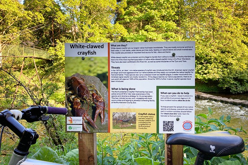
Two ways of crossing the river but phone if you spot any white-clawed crayfish
On emerging from the churchyard, I followed a short, grassy footpath to the river, alongside Bothal Castle which sits on a knoll overlooking a ford on the Wansbeck. At the riverbank there’s an information board telling you all about the plight of the white-clawed crayfish, the red squirrel of British rivers it seems. As with red squirrels, I didn’t see one. The ford can be crossed by stepping stones and lies a few metres upstream while the same distance downstream is a precarious looking wire-suspended footbridge built, apparently, for the rector of St Andrew’s. I asked a chap, who appeared to be local, if it was usable but drew my own conclusion from the look he gave me.
If you’re disappointed by what you’ve been able to see of the castle wait until you’ve ridden away from the village. Look back over your left shoulder when you bear left off the main road, for a great view of it across the fields. The name ‘Bothal’, by the way, derives from the Old English for ‘dwelling’. The manor was awarded to Guy de Balliol by William II (Rufus) in 1095 for services rendered in France (what the dispossessed English landlord had to say about the matter isn’t recorded). The castle we see today dates to the c12th and began life, as many did, as a manor house. As a matter of interest it was Guy’s nephew Bernard who established the castle and town of Barnard Castle in County Durham.
Bothal Castle
In 1343 the house was in the possession of Sir Robert Bertram who was granted a license to fortify it during which time he also built the gatehouse that became the keep. It then passed to the Ogle family. It seems to have had a charmed life because, despite the perceived need for protection in what for centuries was a volatile area – a buffer zone with an often hostile Scotland – it doesn’t seem to figure significantly. Now fully restored, it’s a home and estate office.
The Last Bit
That’s about it for history. The left turn off the main road leads to another steep drop, this time to a narrow bridge across the Wansbeck for the final time. The trick here is to maintain speed and prepare to drop to a comfortable gear because the right-hand bend off the bridge leads directly onto a steep ascent which, at 12%, is long enough to make your legs hurt if you’ve underestimated it. Otherwise it’s a nice climb with a bit of character.
Thereafter things get much easier through the lanes, crossing the A196 before passing through the sprawling village of Hepscott and on to reach the A192 with Morpeth a couple of kilometres away to the right (I’ve included an alternative route if you prefer to visit Morpeth at the expense of missing out on Bothal). I turned left however to enjoy ‘time-trialling’ the few remaining kilometres south to the finish at Hartford.
This website uses cookies to improve your experience. We'll assume you're ok with this, but you can opt-out if you wish.AcceptRead More
Privacy & Cookies Policy
Privacy Overview
This website uses cookies to improve your experience while you navigate through the website. Out of these, the cookies that are categorized as necessary are stored on your browser as they are essential for the working of basic functionalities of the website. We also use third-party cookies that help us analyze and understand how you use this website. These cookies will be stored in your browser only with your consent. You also have the option to opt-out of these cookies. But opting out of some of these cookies may affect your browsing experience.
Necessary cookies are absolutely essential for the website to function properly. This category only includes cookies that ensures basic functionalities and security features of the website. These cookies do not store any personal information.
Any cookies that may not be particularly necessary for the website to function and is used specifically to collect user personal data via analytics, ads, other embedded contents are termed as non-necessary cookies. It is mandatory to procure user consent prior to running these cookies on your website.