Thursday 9th October 2025 | With the year fast reaching a point where “ideal” cycling weather can’t be relied on, I was keen to complete my list of Ray Lonsdale’s “northern” sculptures by which I mean those sculptures north of the River Humber. The first was Sunset for the Common Man or “Big Fella” as he’s known in the Cumbrian coastal resort of Silloth. The other was The Big Dance on the site of the Old Blacksmith’s Shop in Gretna Green, Scotland. Found in the ‘sculpture garden’ it offers a photographic opportunity to couples who still choose to tie the knot at Gretna Green.
My proposed route consisted of three loops linked by two short sections to be traversed in both directions. The highest point on the route, a mere 62 m/203 ft, is near Great Orton approaching the 6-mile mark. Other than that and a few scattered minor hillocks, it’s almost pan-flat. The big loop links a couple of smaller loops, each of which contains a sculpture. There’s a shortcut option close to half-way (38 miles) that reduces the overall distance by around 10 miles.
Most of the route after Silloth, to a point only a couple of miles short of the finish, follows the NCN 72 (Hadrian’s Cycleway) and NCN 7 (C2C)/NCN 10 (Reivers Cycle Route) through the Solway Coast National Landscape (see below). Trunk roads to the north-west of Carlisle are very busy as are brief sections on the cycle routes. With the exception of the A7, approaching Longtown, cycle-paths are available so that you’re not forced to contend with heavy traffic.
I’d originally planned to start and finish in Kingstown Industrial Estate (see Stats at a Glance) before I discovered that Diane’s office in Carlisle was bang on the route. Although she normally works from home I decided that I’d do the ride on a day she’d need to visit the office and I could chauffeur her to work — and use the car-park!
Distance 80 miles/128 km | Height Gain 2221 ft/677 m | Max Elevation 62 m/203 ft (near Gt. Orton) | Going Metalled roads plus a couple of short sections on undressed shared trails. Generally flat with only a few short and relatively gentle gradients | Exposure Very exposed in lots of places | Supplies & Hospitality Abbeytown (GS); Silloth (All); Bowness-on-Solway (PH; Re; Ca); Port Carlisle (PH); Burgh-by-Sands (PH); Monkhill (PH); Rockliffe (PH); Gretna (All); Longtown (All) | Start & Finish (Option): Bankend Road (intersects the cycle path), Kingstown Ind. Est., Kingmoor, Carlisle CA3 0PP (W3W ///posed.rank.nourished) | Grade Moderate | GPS
Solway Coast National Landscape
Most of this visually and physically rewarding route is within the Solway Coast National Landscape. Together with 46 other National Landscapes in England, Wales and Northern Ireland, it was designated and protected by UK law in 1964. The spectacular views across the marshes, wetlands and reserves of the Solway Firth, into Scotland, have been gazed upon by Roman soldiers, medieval knights and Border Reivers as well as generations of Cumbrians with more peaceful intentions. The route visits several historic buildings, most of which are Grade I-listed.Although tranquil today, it was once home to airfields, canals and railways the remains of which can still be found.
An Inauspicious Start
The day I decided upon started out sunny in Durham but became less inviting the further we drove west. A strong, westerly wind was blowing the treetops around but had little effect on the stubborn, heavy clouds. A complete absence of sunshine in Carlisle made the starting temperature feel a tad cooler than comfortable. My agreement with Diane was that I’d aim to be back at the car for around 4.30 pm. I readied the bike, happy that nothing had been forgotten, paid a quick visit to the office loo then set off.
An unsurfaced trail runs on the other side of the fence from the business park offering a nice, relaxed start to the ride. Unfortunately, it didn’t last and soon I was navigating the busy roads using the cycle paths alongside. While they kept me apart from the traffic, it meant that I was crossing roads and roundabouts like a pedestrian with all of the progress (or lack of) that it entailed. This was the first “link section” which took me out across the River Eden and on which I’d be coming back in the opposite direction when heading for Gretna.
It wasn’t long before I was exposed to the full effect of the anticipated headwind which felt every bit as strong as it had looked on the way over. On the positive side, it was a great incentive to get the first 25 miles done knowing that virtually everything else — until the final ten miles or so — would be wind-assisted to some degree. With the effort that pedaling into the wind entailed, it wasn’t too long before I was fully warmed up though I continued to feel somewhat at odds with myself for some reason. It took five miles to reach the lanes and put the heavy traffic behind me.
Just as I was beginning to feel more like my normal self, I came to the tiny village of Woodhouses (7.5 miles) where the first thing to greet me was a “road closed ahead” sign. Not being the type of cyclist who’s dissuaded easily by a “road closed” sign I continued onward, anticipating that all would be well and that, as a cyclist, I’d be able to circumvent any problem. A kilometre or so down the lane I came to a disappointing halt at a place called Pow where a fenced-off construction site completely barred the road ahead. It was obvious that there was no way across so, resignedly, I turned and retraced my route back to Woodhouses.
These early roadworks at Pow weren’t the last
Two-and-a-half miles later I emerged, somewhat depressingly, at a junction directly on the other side of the works. Still, it was done now and the next few miles passed without incident as I continued to beat my way into the wind along lanes where the surface seemed to change with every gust.
I remember crossing the River Wampool for the first time at Moorhouse Mill (11.5 miles) just after passing a hedge-cutting tractor. I spent quarter of a mile trying to avoid freshly cut hawthorn clippings strewn across the road convinced I’d soon be fixing a puncture. It’s been quite some time since I last punctured and I had no wish to see that run of good luck come to an end especially now that I was nice and warm.
Loop 1: Abbeytown, Silloth & The “Big Fella”
I reached the next “link section” at a T-junction near Raby (17 miles) without feeling rim on road. This was the second of my mini objectives, another which I’d be riding in the opposite direction, in this case in about an hour. The next mile took me over the River Waver, into Abbeytown or Holme Cultram as it used to be known. I’m always on alert when I’m visiting places with interesting names and “Holme Cultram” certainly fitted that bill.
In this case the obvious candidate was the Church of St Mary found, just off the road, directly on entering the village from the east. I’ve never seen one like it and was fascinated to learn later, that the Grade I-listed church had been built within the nave of Holmcultram Abbey. As part of a c12th Cistercian monastery the abbey had been dissolved during Henry VIII’s reformation of the English Church. I’d have loved to have had the time to look around but missed opportunities, sadly, would be a feature of the day.
St Mary’s Church, Abbeytown, is built within the ruins of Holmcultram Abbey
I couldn’t hang around as I still felt pressured to build a mileage buffer against my 4.30 pm deadline and it was now about eleven o’clock. So I contented myself with a photo and carried on, making a mental note that Abbeytown also offers a pub and a decent general store close to the road by which I’d return in about an hour’s time.
With only another five miles to go to Silloth, I made myself as small as I could against the wind and got back to pedaling. The countryside was pleasant but, being so flat, offered little in the way of views, not that I could see much beyond a hundred metres ahead when bent forward on the extensions. I hadn’t realised I’d arrived until I was actually on the outskirts of town. Swinging around the rugby club brought me onto cobbled Eden Street. While the cobbles offer a pleasing aesthetic they’re murder on a bike.
At the end of Eden Street is Criffel Street which runs alongside Silloth Green. It has exactly the same teeth-rattling attributes as its neighbour so I decided to switch to the shared path between the road and the green. It was a great improvement but now I had to concentrate on avoiding visitors to a “pop-up” market on the edge of the green, trying not to be distracted by the impressive “broach” spire of Silloth’s Christ Church across the street.
Christ Church, on Criffel Street, Silloth and the nearby WWII memorial (inset) on Silloth Green
Safely past the church, I spied an intriguing piece of public art which I rightly assumed must be associated with the town. It’s a scale replica of a WWII aircraft that turned out to be a Lockheed Hudson. This excellent piece of workmanship was made by local apprentices as a memorial to the WWII role of Silloth airfield. RAF Silloth, as it was known, was an Operational Training Unit (OTU) during the war years before its closure in 1960.
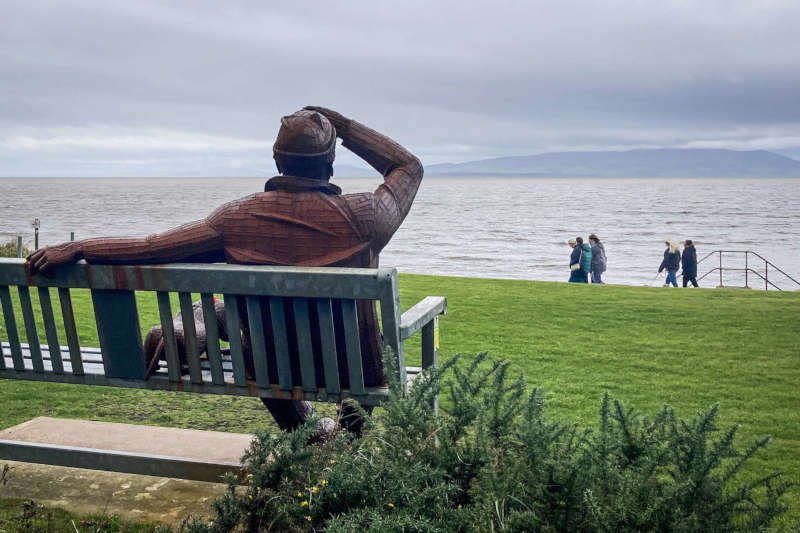
Once I’d taken in the information offered on the interpretation board, the specific reason I’d come to Silloth lay only a short distance away, across the green. Sunset for the Common Man or, as the locals call him, “Big Fella” is hidden behind a clump of trees, overlooking the Solway Firth. It’s an oversized sculpture of a chap and his dog, both sitting on a bench. While the owner’s attention is held by the view across the water, towards Scotland, the dog’s is fixed firmly on the ball at the owner’s feet. It’s just the sort of detail I enjoy so much about Ray Lonsdale’s work which is invariably fabricated from Corten steel, his trademark material.
Disappointment’s a strong word but the absence of a verse of any kind was keenly felt. Many, if not most, of his works include an inscription of some sort; for me they’re as well crafted as the sculptures themselves. Instead, I had to be content with a plaque that implored me simply to “look at that view”. The view was, indeed, superb — even on such an overcast day — but the meagre contents of the plaque were a poor substitute for the reflective insight I’d anticipated.
Nevertheless, sculpture and location offered a great package that was well worth the effort. Mindfully and respectfully ignoring the requests not to climb on the sculpture, I clambered onto his lap to get a photo for scale. I’d tried one sitting beside it but this one was the “money shot”…
“Sunset for the Common Man” (2019) aka “Big Fella” by Ray Lonsdale, Silloth
With as many angles as I could think of covered I set off — cyclo-cross style — over the grass, heading for what was by now a cobble-free road out of town. The route took me unexpectedly through a holiday park then past the former airfield about which I’d just read. Like so many airfields of the period, it’s now a business park and occasional farmers’ market. A repurposed pill-box close to one of the airfield entrances was also noted.
As the distractions receded I glanced at my cycle computer to see that I was fairly tanking along thanks to the tailwind I’d picked up. It would assist me in some degree for most of what remained of the route and meant that the flat, five miles back to Abbeytown was covered in just fifteen minutes.
After retracing the “link section” out of Abbeytown and over the River Waver, I made another left turn at Raby, after 32 miles, onto the second half of the central loop. My intention now was to cover the distance to Bowness-on-Solway as quickly as I reasonably could. By turning north I’d lost the full assistance of the tailwind but what remained was still a great help. With the lanes being so quiet I could tuck further down onto my bar extensions and eke out another mile per hour.
Newton Arlosh & Bowness-on-Solway
At mile 35, still with barely a gradient encountered, I found myself riding through a little village called Newton Arlosh — another intriguing name that fired my curiosity. I had a nagging feeling that I knew the name though doubted whether I’d ever been there. Then it came to me that I’d read it in the history of the church at Great Salkeld, near Penrith, which we’d visited the previous week, specifically to see its fortified tower. Medieval churches close to the Anglo-Scottish were often built with such towers to protect clergy and even villagers against attackers be they plundering armies or, later, reivers. The pamphlet, which I’d photographed, mentioned two other churches both of which, by chance, lay on the route — this one at Newton Arlosh and the other at Burgh by Sands. I’d been aware I’d be passing the latter but hadn’t registered this one.
At the exact point of my epiphany, I glanced to my left and there was the church! I didn’t really want to stop but knew I had to. Despite its Grade I listing it’s a simple building dominated by a barrel-vaulted, crenelated tower (though the crenelations look like typical Victorian additions). Set high in the wall are narrow windows, some of which appear to be more like arrow slits suggesting its defensive priority. The church was renovated from a ruin in 1844 by Sara Losh, who had family connections with the village and was the daughter of an industrialist landowner near Carlisle. She seems something of a driven, polymath for whom marriage was, quite possibly, an unnecessary distraction. Her obvious passion for architectural renovation stretched as far as carving the extraordinary stone eagle perched on the gable end of the nave.
St John’s Church, Newton Arlosh, Cumbria
Back on the road, approaching Whitrigg at 38 miles, I crossed the River Wampool again. It’s much wider here, getting ever wider — within the space of few winding kilometres — as it runs into the estuary of Moricambe Bay (not to be confused with Morecambe Bay). Time to make a decision: turning left at the T-junction would mean I’d continue on the full 80-mile route; turning right would take me to Glasson, knocking ten miles off. It would mean a few more miles into the wind but I had no hesitation in turning left to follow the estuary towards Anthorn, easily located by the towering masts of the radio station adjacent to it.
In 1942 a Royal Naval Air Station was built at Anthorn, being commissioned into the Fleet Air Arm as the very unmilitary sounding HMS Nuthatch. It was responsible for receiving, readying and dispatching naval aircraft including the Vought Corsair and Supermarine Seafire. The airfield was repurposed after the war becoming the radio station that dominates the countryside today.
Slowly the tailwind began to reassert itself as my route turned north, then eastwards. I was following the coastline through the nature reserves of the Solway Coast AONB with the low hills of Dumfriesshire, Scotland, in the distance, across the river. Approaching Bowness-on-Solway, at 47 miles, I began to notice the faintest hint of a shadow as the road rose gently into the village which is built on the site of the Roman fort of Maia/Mais. Today, it marks the western end of the Hadrian’s Wall, offering a tourist information hub, accommodation and a couple of pubs.
We’ve been musing with the idea of walking the length of Hadrian’s Wall but now that we’re into autumn, we’ll probably leave it until next year. This visit would at least offer an opportunity for research and orientation.
The Garrison Bistro, opposite the Tourist Information Centre, Bowness-on-Solway
This part of the coast has a fascinating history involving not only the Romans but medieval kings and their wars, Border Reivers and Georgian smugglers. When the tide is right, it’s possible to cross the Solway — between England and Scotland — on foot. Such journeys were often made for nefarious purposes and, needless to say, there have been more than a few drownings. The road still floods regularly, as attested by numerous flood gauges.
I took a break to have a coffee in the Garrison Bistro (above) from where I emerged, a half hour or so later, into warm sunshine, to continue my journey in the direction of Port Carlisle. Once known as Fisher’s Cross, the village changed its name to something more in keeping when the canal from Carlisle was built. Its sleepy atmosphere today suggests that it could do worse than change it back.
Drumburgh & Burgh by Sands
After riding past the junction that would have been my exit had I taken the Glasson short-cut, I arrived in Drumburgh, just after the 50 mile mark. On cresting the low rise into the village, my attention was immediately drawn to an imposing stone building on the roadside. Referred to as “Drumburgh Castle” it stands close to the site of the Roman fort of Congabata (there are several versions of the name) and is actually built from its stone. Although never a castle as such, it started life as a manor house, fortified by Robert le Brun in 1307, then remodeled by Thomas Dacre in 1518 as a “strong house”. Today, the Grade I-listed building is part of a working farm.
Drumburgh Castle (centre) on the site of the Roman fort of Congabata
Drumburgh is separated from Burgh by Sands by a three-mile stretch of pan-flat road alongside which runs a distinct embankment that was once the track bed of the Port Carlisle Dock & Railway. It operated between 1854 and 1964 having been constructed over an earlier canal. The section continues to follow the course the Roman Wall, between milecastles 76 and 73. Assisted by a full-on tailwind, it took less than ten minutes to cover it.
St Michael’s Church in Burgh by Sands is yet another Grade I-listed building and another constructed on the site of a Roman fort — in this case, the fort of Aballava. What makes the c12th church fascinatingly unique is that it is where the body of Edward I — the “Hammer of the Scots” — was laid out after his death on nearby Burgh Marsh in 1307. A statue of the English king can be found near the Greyhound Inn in the village. There’s a more substantial monument — which I didn’t have time to visit sadly — a couple of kilometres to the north, on Burgh Marsh.
The body of Edward I (inset) was brought to St Michael’s Church, Burgh by Sands
Back on the bike, I was no more than a mile down the road when I came across my second “road closed” sign at Monkhill. Again I chose to push on, hoping this time to quickly see the cause of the closure. Once again, I found it at the other end, a mile away in Kirkandrews-on-Eden. Happily, it amounted to nothing more than domestic gas works which I was able to ride around without any trouble.
Just over a mile out of Kirkandrews I began to notice the increasing rumble of heavy traffic. This meant that I was approaching the end of the central loop, bringing me back to the roadside cycle paths on which I’d ridden out in the relative gloom that morning. By now it was around 2 pm and much brighter; with only 23 miles to go, I felt it was looking good to make the time cut.
Loop 3: Gretna, “The Big Dance” & Arthuret Church
At 58 miles, I recrossed the River Eden before turning north on the NCN 7/NCN 10. Most of this final twenty mile loop — with “The Big Dance” at the half way point — is on one or other of these major cycle routes.
The first mile or so, past the drearily-named Cargo is, likewise, uninspiring though relatively flat (the cycle path is currently being improved alongside the busy road). Approaching Rockcliffe, there are a few undulations that stand out only because the miles up to that point have been so flat. On entering the village, I absentmindedly continued on the main road when I should have switched to an off-road section alongside the River Eden. So, I turned back up the slight hill I’d just come down and switched to the track. At the bottom of a short hill I came to a footbridge that I found to be completely submerged by the river — as was the track for as far as I could see beyond it. Time to turn around.
NCN 7 submerged by the River Eden at Rockliffe, Cumbria
Getting beyond Rockliffe was a breeze on the road. From there, the four-mile journey to Gretna includes a dead straight, mile-long section of quiet country lane that’s flat and sheltered. It then transitions to a couple of miles alongside the M6, where you cross the River Esk (Eden and Esk both enter the Solway from England if you’re interested). Although you can still hear the traffic on the motorway it’s quite a nice ride.
The border with Scotland — on the southern outskirts of Gretna — is delineated by the River Sark. Upstream, it crosses from the Sark to the Esk via an arbitrary line known as “Scots Dyke”. During the times of the Border Reivers in the c16th, Scots Dyke was a boundary line for what was referred to as the “Debatable Land”. For decades it was a lawless area, disputed by both England and Scotland, where some of the most notorious reivers — notably Grahams — operated.
The town of Gretna began life as HM Factory Gretna, a nine-mile-long First World War munitions site stretching from Longtown in England to Eastriggs in Scotland. It was the largest in the world at the time. Sir Arthur Conan Doyle infamously described the explosives it manufactured, by combining guncotton and nitroglycerin, as “The Devil’s Porridge”. You can learn more about it by visiting the Devil’s Porridge Museum at Eastriggs.
My business however, lay beyond Gretna, on the other side of the M6 motorway, at The Old Blacksmith’s Shop in Gretna Green (67 miles). It owes its fame to Lord Hardwicke’s Marriage Act of 1753 which made tying the knot more difficult in England than it was in Scotland. It became common for couples, not yet 21 or lacking their parents’ consent, to elope to the nearest town north of the border. In this case it was Gretna Green where “quickie weddings” are still a big seller.
Most prominent in the “sculpture garden” is “The Big Dance”. A pair of clasped hands — seemingly male and female — on arms stretching skywards, form an arch that’s well over ten feet high. Installed in 2010, it’s one of Lonsdale’s earliest works. Once again, the material is Corten steel. The verse fragment on the plaque beneath the arch is brief but sufficiently intriguing to get a “yes” from me. It reads “…neither had the notion that the big dance had just begun…”.
“The Big Dance” by Ray Lonsdale (2010), Gretna Green
At the time of my visit the sculpture was the subject of international legal controversy in that an almost identical one had been created in New Zealand. That artist was in the process of being sued — quite reasonably when they’re compared — by Mr Lonsdale.
By this point in the afternoon — around 3.15 pm — the clouds were receding and the autumn sun was shining ever more warmly. Only twelve miles remained; even with a slight headwind I should have no trouble keeping to my self-imposed deadline, especially in such benign conditions.
If I regret anything about the ride it’s not taking the time to seek out the memorial cairn — not far from the sculpture garden — for the Quintinshill Railway Disaster of 1915. On a fine day in May, over two hundred people — most of them soldiers bound for Gallipoli — were killed in a tragic incident involving the destruction of three trains. It’s officially the worst rail disaster in British history. I can’t help but think if the memorials might have read any differently had the soldiers made it to Gallipoli, which turned out to be a disastrous campaign.
This final section, still on the NCN 7, starts on quiet lanes where, without realising, I recrossed the River Sark, back into England. There’s a lengthy section of peaceful woodland before it’s necessary to confront the busy A7 trunk road. With no cycle path option, the next kilometre to Longtown might possibly have been the most stressful of the day.
Although the A7 runs straight through the town, once you’ve crossed the River Esk, traffic calming measures make cycling more tolerable. Preserving its 20th-century military heritage, Longtown is best known today for being the location of a large Defence Munitions Centre (DMC).
Back in the lanes on the other side of town, at the top of a small brow, I came upon Arthuret Church — dedicated to St Michael & All Angels. Built in the Perpendicular style, it dates to 1609, it’s medieval predecessor having been devastated during the worst excesses of the Border Reivers. James I of England & VI of Scotland was personally involved in raising the money for its reconstruction though it’s thought that his locally born jester — Archie Armstrong — who’s buried in the churchyard, may have influenced him. I was very surprised to find that, despite its history, the church is only Grade II-listed.
St Michael’s & All Angels Church at Arthuret, near Longtown, Cumbria
Had I been able to resist the temptation to inspect its lichen-mottled headstones for ancient reiver names like Graham, Armstrong and Bell (all of which I quickly found), I’d have easily maintained my schedule. In the event it was another twenty minutes or so until I was back on my way. This left me with about half an hour which, although tight, I felt was still doable.
Barely more than a mile down the road, just as I reached the second, and final, unsurfaced section of the route (ignoring the trip across the green to visit “Big Fella”) I received an anticipatory phone call from Diane. Mindful of the idea that I could now defray the blame for any delay, I confirmed that all was well, and that I’d arrive on time — more or less — and carried on.
Just as I was beginning to think that I was in the clear, on emerging from that very pleasant section of grassy trail, I came across my THIRD “road closed” sign. I was so close to finishing that I felt it couldn’t possibly be a problem so continued. True to form, there, at the far end of the closure, was another construction site that completely barred my way — just like the first.
And, just like the first, I had no choice but to turn around and go back, for a mile and a half this time. While it helped put me well over the 85-mile mark it meant that I eventually pulled into the car-park around half an hour later than anticipated. There was no pressure from Diane, who seemed happy to see me back but, until the last few miles, I’d felt that it had all been under control. I’m experienced enough to have known better.
Roadworks apart, it had been a great ride, probably as rewarding and pleasant as any I’ve done, particularly given the features I’d visited — planned and unplanned. Some might feel that it’s longer than they’d like but the terrain and options to manipulate and shorten it make for 80 very accessible miles. Although I used a private car-park, there are many options in the Kingstown Industrial Estate to the south which I’d originally intended to use. I could write so much more but it’s become way too long anyway. I’ve given the route a ‘moderate’ grade but only for the mileage involved. For anyone who wants to increase their distance without too much stress (apart from roadworks) this is a great way to do it.
This website uses cookies to improve your experience. We'll assume you're ok with this, but you can opt-out if you wish.AcceptRead More
Privacy & Cookies Policy
Privacy Overview
This website uses cookies to improve your experience while you navigate through the website. Out of these, the cookies that are categorized as necessary are stored on your browser as they are essential for the working of basic functionalities of the website. We also use third-party cookies that help us analyze and understand how you use this website. These cookies will be stored in your browser only with your consent. You also have the option to opt-out of these cookies. But opting out of some of these cookies may affect your browsing experience.
Necessary cookies are absolutely essential for the website to function properly. This category only includes cookies that ensures basic functionalities and security features of the website. These cookies do not store any personal information.
Any cookies that may not be particularly necessary for the website to function and is used specifically to collect user personal data via analytics, ads, other embedded contents are termed as non-necessary cookies. It is mandatory to procure user consent prior to running these cookies on your website.