
Teesdale Way Section 6 (Barnard Castle to Whorlton)
Introduction
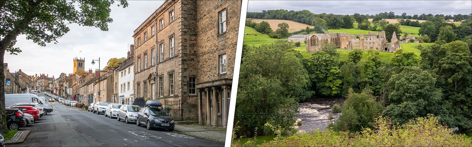
Section 6 of the Teesdale Way is the shortest of all the Teesdale Way sections, linking the market town of Barnard Castle with the village of Whorlton in County Durham. Like the previous section, this one is another figure-of-eight loop, making it an excellent choice for a day-walk. Unfortunately, since December 2020, the bridge over the Tees which serves as the “official” finish for this section, has been closed for renovations and, until it is recommissioned, that’s no longer an option. There’s still the circuit between Barnard Castle and Abbey Bridge but the route to Whorlton lies via the north bank of the Tees only.
The route, which is no more than gently undulating, is quite sheltered and, at most times of the year, offers relatively firm going — mainly through fields and woodland. The GPS file we provide is for the complete figure-of-eight route although the stats given below — and the route described — are for the linear trail which starts by heading downstream on the north bank of the river before crossing Abbey Bridge to the south bank. Until the bridge is reinstated (probably in 2026) it’s necessary to stay on the north bank of the Tees after Abbey Bridge. You can keep up to date with the situation at Whorlton Bridge HERE.
Stats at a Glance
Distance: 6.8 km/4.3 miles | Height Gain 59 m/194 ft | Maximum Elevation 138 m/453 ft (Barnard Castle) | Going Generally good though muddy in places. Sheltered on trails, tracks and road through woodlands, parkland and farmland | Navigation (OS Maps Explorer OL31; Explorer 304; Landranger 92); GPS File | Hospitality & Supplies Barnard Castle (All): Whorlton (PH*) | Start Demesnes Recreation Area, Barnard Castle NZ 050160 (w3w: inflation.validated.warblers)| Finish Whorlton Bridge, Whorlton NZ 106145 (w3w: marine.jaws.technical) | Grade Moderate | GALLERY
Trail Updates
The following updates have been published by The Durham Cow for this section: 140725
Description
As per the directions published in our guidebook: from the Demesnes recreation area in Barnard Castle, the way-marked trail follows the river downstream towards Abbey Bridge, through Demesnes Mill Farm, past the site of a former flax mill near the waterworks then, shortly afterwards, the ruins of c12th Egglestone Abbey across the river. You can visit the site easily on the figure-of-eight trail on the way back. In October 1346, the abbey, which belonged to the somewhat impoverished Pre-monstratensian order, was a mustering point for the English army prior to its successful action against the Scots at the Battle of Neville’s Cross on the outskirts of Durham.
Abbey Bridge is high, narrow and controlled by traffic lights at either end. It spans a limestone gorge that’s a rewarding place to explore (from the woods before the bridge) but if you’ve decided not to there’s a nice view from the bridge itself. When polished, the limestone, which has been extracted from quarries in the area for centuries, is known as “Egglestone Marble” (similar to neighbouring Weardale’s “Frosterley Marble”). Both types are found in religious buildings locally and further afield.
As I’ve said, unless Whorlton Bridge has been opened, you’ll need to cross the road without crossing the bridge and continue on the same side of the river. You’ll pass a local lime kiln in the wood and—a bit later—the path leading down through another wood to a quiet, sheltered spot opposite the “Meeting of the Waters” mentioned below. Later, there’s a nice view across the river to Mortham Tower and the nearby site of a proposed Roman camp, plus you cross a footbridge over an unnamed beck where you’ll find a couple of the “Marking the Parish Boundaries” boundary markers. If there had still been a pub in Whorlton the trail on the north side of the river would have made it a bit closer.
If Whorlton Bridge IS open then you might choose to cross Abbey Bridge—as per the guidebook—and continue through the woods on the south side of the River Tees. There are a couple of pairs of boundary markers on this side, so look out for them. After swapping the woods for the lane on the northern edge of Rokeby Park you might get a glimpse of the Palladian-style house that the amateur architect Sir Thomas Robinson designed and had built for himself.
In the c14th the park belonged to Sir Thomas de Rokeby, a senior commander at the Battle of Neville’s Cross mentioned earlier. Then, the village of Rokeby would, perhaps, have supplied men for the army; today however, only the base of the stone cross that once belonged to St Michael’s Church remains. Further along the lane you cross the River Greta via Dairy Bridge: in his 1770 publication A Six Months Tour through the North of England Arthur Young mentions a “tea-room” in the cottage by the bridge.
A short distance downstream from the bridge, the boulder-strewn confluence of the Greta and Tees has long been known as the “Meeting of the Waters”, the boulders having been deposited by the catastrophic “Great Flood” of 1771. At the turn of the c18th, this site and many others in Teesdale, attracted artists including Turner and Cotman as well as Sir Walter Scott who used it as inspiration for his epic poem Rokeby. Later, the area was to provide a great deal of material for Charles Dickens’ novel Nicholas Nickleby.
Entering Mortham Park, on the other side of the bridge, the trail passes close to Mortham Tower, a fortified manor house dating to the c14th. It’s located close to the proposed site of another deserted medieval village which, like Rokeby, was cleared by Sir Thomas Robinson in the c18th. Leaving the park, the trail passes above what may have been a Roman encampment in the fields that slope northwards down to the river (it could just as easily be medieval however and awaits further investigation). Beyond the Rokeby/Whorlton boundary markers, the final field approaching the bridge at Whorlton is the site of yet another deserted medieval village—Thorpe-in-Wycliffe.
Finally, it’s worth mentioning that in the field on the other side of the road, next to the bridge is the Thorpe Light Railway. For years up to the 1990s it was also a popular outdoor swimming attraction known as “Whorlton Lido” the loss of which is still felt keenly by some folk.