
Weardale Way Section 14 (Deptford to Roker)
Introduction
Section 14 of the Weardale Way links Queen Alexandra Bridge, Deptford – close to the centre of Sunderland – with the finish (or start) at the Bede Memorial Cross in the coastal resort of Roker. So much heritage is squeezed into the shortest, most urbanised section of the Weardale Way that it can leave you bewildered. There’s no way-marking for the Weardale Way however but, given that the city is undergoing a lot of change, the impact’s hardly noticed. Although short and urban this part of the trail involves a surprising amount of climbing.
Because of the changes that are taking to the city and to the route, I’m not going to alter the description (which I’ve highlighted in red) between the start at Queen Alexandra Bridge and Wearmouth Bridge until things have settled. Until then, the most recent information will be found in any updates. The GPS will however, offer the most up-to-date route.
Stats at a Glance
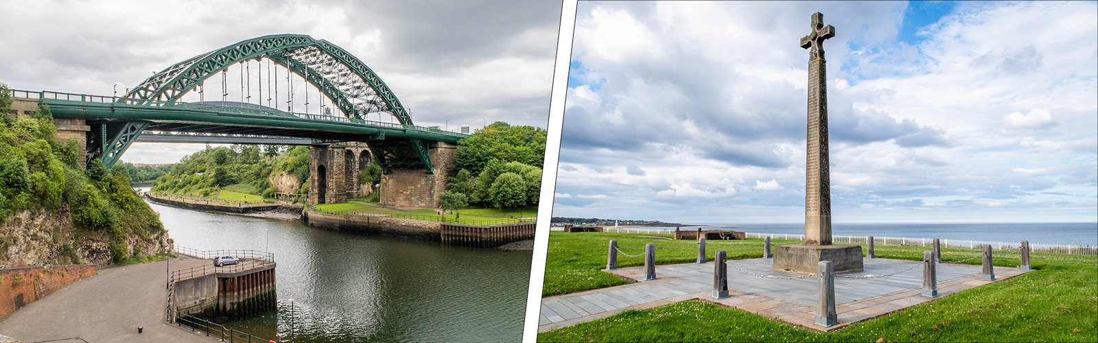
Distance 5.6 km/3.6 miles | Elevation Gain 74 m/242 ft | Maximum Elevation 30 m/99 ft (Wearmouth Bridge) | Going Firm on roads and footpaths through urban and coastal | Exposure Fairly sheltered | Navigation (OS Maps Explorer 308; Landranger 88); GPS File | Hospitality & Supplies Deptford (PH); Sunderland (All) [0.5 km]; Monkwearmouth (All) [0.5 km]; National Glass Centre (Ca); Roker (All) | Start Queen Alexandra Bridge, Deptford NZ 382575 (w3w: curiosity.move.ducks) | Finish Bede Memorial Cross, Roker NZ 406593 (w3w: finishing.worm.asleep) | Grade Moderate | GALLERY
Trail Updates
The following updates have been published by The Durham Cow for this section: 030525; 23/03/22; 18/06/21
Description
From the south end of Queen Alexandra Bridge the route heads east on the newly established link road from the Northern Spire Bridge, past the entrance to historic Webster’s Ropery and onto Deptford Terrace. After a short distance, the route begins to descend, past the original iron gates of what was Laing’s Shipyard, towards The Saltgrass pub. At this point it turns off the road and takes to the riverside opposite Sunderland FC’s Stadium of Light which, until 1993, was occupied by Wearmouth Colliery – the last operational pit in the Durham coalfield. This section of the river once bristled with infrastructure for loading coal onto river-borne colliers, the most obvious remnants of which are the staithes and brickwork below the stadium.
Heading downstream, the route passes Galley’s Gill – now known as Riverside Park. Until 1967, this was the site of the Hetton & Lambton Drops, to which trains hauled trucks filled with coal, to be loaded onto ships waiting on the river, within the shadow of Sunderland Power Station. The route then slips beneath the Wearmouth bridges, first the ‘hog’s back’ railway bridge followed by the third incarnation of the road bridge before ascending to the bridge deck at Pann’s Bank via a cobbled ramp. Next to it is a large mural picturing S.P. Austin’s specialised ‘pontoon’ repair facility the location of which can be seen cut out of the quayside.
Over the bridge, across the river, the route descends via steps off the bridge, to the riverside where it joins the C2C cycle route. As recently as the 1980s the area, now given over to the University of Sunderland’s Sir Tom Cowie campus, was dominated by J L Thompson’s shipyard. Today there are a growing number of sculptures that reference the period, most notably (for me at least) works by local sculptor Ray Lonsdale who has two oversized pieces – ‘Dead & Gone’ and ‘Launch Day’ – alongside various others known collectively as ‘Shadows in another Light’. Inland behind the university is the famous monastery site of St Peter’s Church, once home to Bede – England’s first historian – whose tomb can be found in Durham Catheral’s Galilee Chapel.
Back on the riverside the route passes the National Glass Centre. Opened in 1998, to commemorate Sunderland’s long association with glass-making, it looks set to close in 2026. After passing ‘The Red Room’ sculpture, you reach North Dock Marina where – protected within the Activity Centre – is an amazing petrified tree growing out of the harbour wall. Around the headland, by Sunderland Yacht Club’s HQ, you’ll find Roker’s sheltered bathing beach, once reserved exclusively for genteel Edwardian ladies. Further on, towards Roker Pier, is another notable sculpture, Andrew Small’s enigmatic ‘C’ constructed of polished, black granite and inspired by Bede’s work calculating Easter within the religious calendar. Unless you were to continue across the beach to wet your wheel in the sea it also serves to mark the eastern end of the C2C cycle route.
The Weardale Way however continues to the end of Marine Walk and Roker Ravine, the beach-front entrance to Roker Park. You can either use the steps to the promenade or continue into the park and wind your way back to the road. The Bede Memorial Cross stands stiffly aloof, on the headland, a short distance along the road towards Seaburn. This fine memorial of which there are similar examples elsewhere in the North-East marks the end (or beginning) of the Weardale Way.