
Weardale Way Section 11 (Durham to Chester-le-Street)
Introduction
Section 11 of the Weardale Way starts from Baths Bridge in Durham City and finishes at the east pier of the now demolished Old Lumley Bridge opposite Riverside Park in Chester-le-Street. Although this section undulates gently for the most part it includes a short, steep descent into the Wear Gorge at Finchale Priory about half-way through. The going is relatively easy, the roads relatively quiet though some sections don’t have footpaths. This section generally follows way-marking for Cuddy’s Corse and Northern Saints Trails
Stats at a Glance
Distance 13 km/8 miles | Elevation Gain 131 m/430 ft | Maximum Elevation 75 m/246 ft (Great Lumley) | Going Generally firm with potentially wet, muddy sections on roads, footpaths and trails through woodland, farmland, urban, parkland | Exposure Fairly sheltered | Navigation (OS Maps Explorer 308; Landranger 88); GPS File | Hospitality & Supplies Durham (All); Finchale Priory (Rf*); Great Lumley (Ca; GS; PH); Chester-le-Street (All) [0.5 km] | Start Baths Bridge, Durham NZ 278425 (w3w: hurray.spark.pirate) | Finish Old Lumley Bridge, Chester-le-Street NZ 284509 (w3w: mutual.rods.give) | Grade Moderate | GALLERY
Trail Updates
The following updates have been published by The Durham Cow for this section: 100525
Description
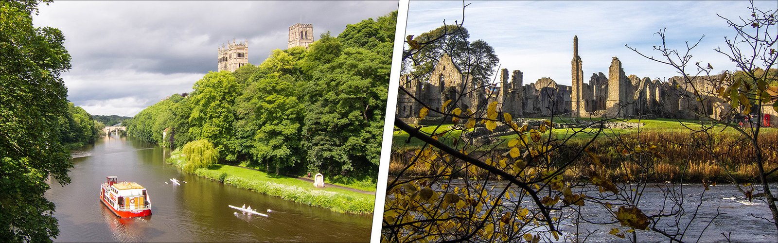
From Baths Bridge the route heads under New Elvet Bridge past the mooring site for the Prince Bishop river cruiser and Brown’s boathouse. Elvet Bridge is the oldest bridge in Durham, dating to 1160 and once incorporated a gaol, or ‘house of correction’. A bit further downstream is the soaring Kingsgate Bridge, designed by the esteemed Anglo-Danish architect Ove Arup who had such a connection with the bridge that he had his ashes scattered from it. St Oswald’s Church sits high on the the other side of the river and, at the tip of Durham’s distinctive peninsula, is Shipperdson’s Cottage, a riverside folly popularly known as ‘The Count’s House’ referencing Joseph Boruwlaski, a celebrated c19th resident of Durham, who was only 3′ 6″ tall.
To the right, at the top of the ramp onto Prebends Bridge, is The Watergate which leads onto North Bailey inside Durham’s medieval city walls. The bridge itself offers one of several iconic views of Durham Cathedral with the Fulling Mill below it. There’s a short verse by Sir Walter Scott inscribed on a stone at the western end of the bridge. Over the river the trail continues downstream past South Street Mill (another iconic photographic opportunity) to Framwellgate Bridge and the site of Durham’s oldest river crossing. Downstream of the weir, Milburngate Bridge conducts traffic through the city while, further downstream still, Pennyferry Bridge is the last, and most recent, of Durham’s ten bridges.
Shortly after leaving Pennyferry Bridge the route passes the foot of Sidegate, a steep, cobbled lane off Framwellgate Peth on the northern outskirts of the old city. Not too far away is the entrance to Crook Hall, one of Durham’s oldest and most historic dwellings, now in the possession of the National Trust.
After all that, there’s a bit of a lull as the route follows a quiet access road past the waterworks on the river’s floodplain before a short climb to Frankland Farms where it switches to a woodland trail through what’s known locally as ‘The Scrogs’. The presence of a former railway at Low Newton (Frankland) Junction – now a nature reserve – is indicated by four tall, concrete posts that once supported heavy gates. Beyond the trees to the right is Brasside Ponds, a tranquil reserve comprising two deep lakes created from of a former brickworks.
The route then passes between two prisons – HMP Low Newton on the left and HMP Frankland on the right. On reaching Frankland Lane at Brasside, the route continues past a complex of squat, Cold War ammunition bunkers – now in private ownership – before arriving at a holiday park within which are the ruins of Finchale Priory, an extension of the Benedictine monastery at Durham. You cross the River Wear via an impressively constructed wooden footbridge close to the foot of a long flight of stone steps, lifting you out of the deep sandstone gorge.
At the top of the steps, the route turns left on Cocken Road, then right, onto Cocken Lane, heading towards Great Lumley. Both lanes have become increasingly busy and neither has a footpath so take care. Half a mile later the route takes to a narrow trail over fields to reach the village of Great Lumley. We suggest a route through the estate onto Front Street, where there’s a parade of shops with a nice cafe. You leave the village via an intriguing wooden sculpture for which I’ve been unable to find any information despite the fact that it’s been there for over a decade.
Descending through the fields to Chester-le-Street offers long views towards Lumley Castle, Gateshead and – if you look carefully – the Angel of the North. You rejoin the River Wear a short distance upstream from Durham Cricket’s Riverside Stadium (on the opposite side) then pass under New Lumley Bridge to reach the finish of the section on the east abutment of the now demolished Old Lumley Bridge.