As a passionate cyclist I’ve long been wanting to add a cycling alternative to the walking trails supported on this site – the Weardale Way and the Teesdale Way. I’m happy to announce that the Palatine Pedal is the result. It’s a long-distance, multi-terrain cycle ride around the old County Palatine of Durham devised here at The Durham Cow in 2024. While it includes many of the features introduced in both walking trails – and many that aren’t – it also offers a robust cycling challenge in some of the North East’s best biking country.
At 190 miles the Palatine Pedal is a long way for a day-ride but, thanks to the transport links woven into it, it can be broken down quite easily. Using dedicated and shared cycling infrastructure, it visits major cities and towns, starting and finishing in Durham, and including Seaham, Sunderland, South Shields, Jarrow, Newcastle/Gateshead, Consett, Allenheads, Middleton-in-Teesdale, Barnard Castle, Stockton-on-Tees and Hartlepool. Elsewhere, it passes close to Darlington and Middlesbrough thus ensuring plenty of hospitality, transport and route options.
The Palatine Pedal in a Day on…
Killhope Cross, Weardale
In the east – on the North Sea coast – are miles of wide, sandy beaches found – in the northern section – between the mouths of two of the region’s three major rivers, the Wear and the Tyne. Elsewhere, the route follows the Tees for most of its length, departing a few miles short of its mouth to Hartlepool, and more beaches.
In fact, rivers more or less define the route: to the west, deep in the valleys of the North Pennines, you’re much closer to their respective headwaters – particularly the Wear and the Tees. Elsewhere, you’ll see a lot of the Tyne, a bit of the Derwent, a fleeting glimpse of the Team but you’ll need to keep your wits about you to identify the Lune and Balder, even as you cross them. I suppose I should also mention the nascent East Allen with flows through Allenheads. The dales through which they run – Tynedale, Derwentdale, Weardale, Allendale and Teesdale – are separated by high, often heather-clad ridges, for which you’ll definitely need your climbing legs.
The countryside itself is ancient: (Carboniferous (~350 million years) in the North Pennines and central Durham; Permian (~300 million years) towards the East Durham coast and Triassic (~250 million years) entering the low-lying terrain of the Tees Lowlands. The smaller lumps and folds that might have you sweating or swearing are provided compliments of more recent periods of glacial activity. High moorlands in the west (including England’s highest public road), fall away eastwards to a cultivated, urbanised landscape, while a steep plateau – north of Hartlepool – attempts to block progress towards the coast. Throughout, there’s a fascinating swathe of history to be enjoyed and explored – from the Romans, through the industrial revolution, right up to the modern era where change continues apace.
Land of the Prince Bishops
It won’t spoil your enjoyment of the route if you don’t, but if you’d like some historical background then read on… The route encompasses the pre-1974 ceremonial county of Durham, ancient domain of the haliwerfolc or ‘people of the saint‘. The saint in question is St. Cuthbert, c7th Bishop of Lindisfarne and patron saint of Northumbria, who was frequently called upon to protect ‘his’ people whenever danger threatened. He lies today – together with his biographer Bede, the c8th historian-monk – in Durham Cathedral, always within earshot of his flock, not far from the start of the route.
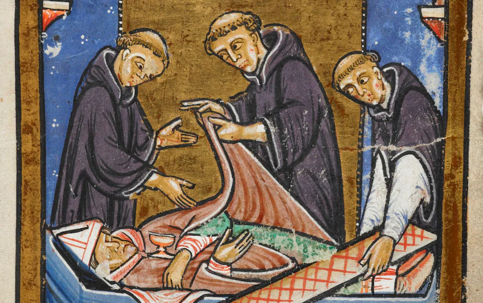
Monks view the body of St Cuthbert
It was in the c9th, that the monks of Lindisfarne – the community of St Cuthbert as they came to be known – were forced to leave the island to avoid the depradations of Viking raiders, taking with them the long-dead but miraculously uncorrupted body of their bishop, Cuthbert. After travelling around the north for seven years, during which time the cult of St Cuthbert began to mature into a serious generator of wealth, they established themselves at Chester-le-Street in 883. Here they stayed for over a century before finally arriving in Durham – via Ripon – in 995 AD.
Even before they left Lindisfarne, the community had begun to acquire – through gift and purchase – estates around the North – particularly between the Tyne and the Tees. Known as the Liberty of Durham or the Patrimony of St Cuthbert these estates – between Anglo-Saxon Bamburgh and Viking York – proved to be rich in minerals such as coal, lead, iron and silver, generating a level of wealth – directly or through leases – that ensured the Bishops of Durham would be some of the most influential courtiers in England.
In 1071AD, Aethelwine – last of the Anglo-Saxon bishops of Durham – was forced to flee from England, whereupon the king – William the Conqueror – appointed one of his Norman barons – William Walcher – to the post. In 1075 he sold Walcher the earldom of Northumberland so uniting secular and spiritual authority in a single office and creating a ‘proto’ prince-bishop although the actual term ‘prince-bishop’ may not have been used until after the demise of the palatinate.
There’s more to it than that but it’ll do for our purposes. So, what’s a County Palatine? The term ‘palatine’ means ‘of the palace’, a palatinate in this context, being a medieval jurisdiction administered, or ruled, by a senior nobleman appointed by the king to govern on his behalf. Effectively, the appointee, who was often a nobleman in his own right – usually an earl, in England – WAS the king and was permitted to create the necessary offices including an exchequer, judiciary and military.
In fact, Durham – during the medieval period – was documented as being a region where ‘the king’s writ did not run’. Here it was the Bishop of Durham who had primacy. In return for that privilege he swore loyalty to the king and, most importantly perhaps, provided a military force to defend the border with Scotland. For exactly this reason it was the Bishop of Durham who built Norham Castle on the River Tweed in an exclave of the palatinate known as ‘Norhamshire’ (there are others such as neighbouring ‘Islandshire’ (Holy Island) and ‘Bedlingtonshire’ (also in Northumberland) as well as Craikeshire, and Howdenshire, in North and East Yorkshire respectively).
“There are two kings in England, namely, the lord king of England wearing a crown as symbol of his regality and the lord bishop of Durham wearing a mitre in place of a crown…in the diocese of Durham”. William de St Botolph, Steward to Bishop Bek (1302)
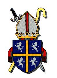
Bishop of Durham’s Coat of Arms
As relations with Scotland began to improve during and after the c16th, Durham clung to its palatine status. The situation began its irrevocable decline however, in the latter half of Henry VIII’s reign following the Dissolution of the Monasteries (1536-41). From then on erosion of the bishop’s powers was remorseless until they were finally abolished in the Durham (Counties Palatine) Act 1836.
This important historic connection is maintained formally in the Bishop of Durham’s coat-of-arms which incorporates a crown and sword as well as the more conventional bishop’s mitre and crozier; informally it’s most notable on road signs scattered throughout a somewhat contracted county such as the one pictured above at Killhope Cross, close to the route. This venerable region is today comprised of County Durham together with the Metropolitan Boroughs of Tyne and Wear (South Tyneside and City of Sunderland), Darlington, Stockton-on-Tees and Hartlepool.
The Cycling Challenge in Brief
Even with the distractions offered by its many features, at 190 miles (306 km) and almost 12,000 ft (3639 m) of ascent on a variety of surfaces (though mainly road) the Palatine Pedal will challenge the fittest cyclist, depending on how it’s ridden. While it can be done in a day it’s probably best experienced by breaking it down into shorter, planned sections when you’ll be able to regard the highest hills as merely delivering the best views. I’ve suggested Freeman’s Place in Durham – close to the railway station – as a starting point but you could start similarly from Newcastle/ Gateshead, Sunderland, Darlington or Middlesbrough.
Part of the attraction of this route – in my humble opinion – is the region’s varied geography, where several major rivers – flowing eastwards to the North Sea – have cut into the landscape creating a series of high ridges. The resulting dales, valleys and denes all offer their own brand of challenge. While following them is often quite easy, crossing them requires a bit more effort – or lower gears.
The further upriver you go the harder it gets, particularly on the Tyne, Wear and Derwent. The Tees however, is slightly different: it’s still a challenge upriver but lower down – between Darlington and Middlesbrough, in what’s known as the Tees Lowlands – the cycling is generally much easier, all the way to Hartlepool. Conversely, much of the high ground is remote and exposed – with little cover of any sort. Prevailing winds blow west to east – the same direction in which the rivers flow. Riding it in the direction I’ve shown means that you’ll have an easier second half, particularly from Chapel Fell (the highest point of the route) all the way to Barnard Castle – a nice reward for the effort it takes to get there!
The North Pennine gradients are characteristically long, often with steep sections, and winding at times. Up or down, they need to be treated with respect if you want to get the best out of them. Surfaces vary – from smooth tarmac to gravel, loose ballast and even rocks – plus there are fun features like pot-holes, drainage channels, gates, sheep and other furry or feathery friends to contend with.
The map below offers a number of route choices, on and off-road. I’ve prioritised what I believe to be the optimum route but you might disagree. Clicking on the options (in red) will load them on the map in Plotaroute. Traffic-wise it can be quite busy – dependent on timings – particularly the eastern half of the route. It’s for this reason that I’ve used so many cycle and shared use paths. Generally it makes for slower going (access barriers of all types abound) so depending on how you feel about traffic, you might prefer to use the road – or a bit of both. Hospitality options are virtually limitless in the eastern half but need to be considered more carefully in the west.
It’s always worth remembering that ‘change is constant’, particularly on long-distance routes like this. Although I’ll try to publish updates where appropriate it won’t always be possible as I rely on feedback from users (although I frequently use sections of the route when cycling). Let me know any issues (long term ones particularly) that you’ve had to deal with or that might be impending. I can’t promise to resolve them but I’ll help where I can, at least by letting others know. On that note, if you notice anything wrong with the details I’ve compiled here then, once again, please let me know.
When planning my own routes I find Causeway one.network to be a very useful site for anticipating road works and similar diversions.
Stats at a Glance
Distance 190 miles/306 km | Height Gain 11,939 ft/3639 m | Maximum Elevation 622 m/2041 ft (Chapel Fell, Weardale) | Number of Sections 11 | Average Distance per Section 17 miles/27 km | Longest Section Section 11 (24 miles/39 km) | Shortest Section Sections 7 & 9 (10 miles/16 km) | Route File (on Plotaroute)
Click the PLAY arrow on the map to view the route dynamically together with some non-sponsored hospitality suggestions (sections drawn in red on the map are clickable route options). Change from kilometres to miles by clicking appropriately in the window, bottom left. Once the route is playing, click on the menu in the window (top right) for more options including links to the FREE ROUTE FILES which you can download in a variety of formats. Alternatively, click the link to the Route File in Stats at a Glance to go directly to the page on Plotaroute (scroll down to view the downloadable file types).I
I’ve graded the sections ‘easy’, ‘moderate’ and ‘challenge’ based on my (and my wife’s) perception of distance, ascent (length and grade), surface and skill/confidence. Of course it’s highly subjective – a bit of fun really, though it might help some. The sections listed as ‘easy’ should be able to be managed comfortably (in terms of effort at least) by ‘occasional cyclists’ allowing sufficient time, even if they need to push on short gradients (there’s nothing wrong with pushing, as long as you’re still enjoying it). Even so, you’ll see there are only a few sections that I believe qualify as ‘easy’.
Section 1: Durham to Seaham (13 miles/21 km | 757’/231 m | Moderate | Route File)
Apart from a fairly tough climb to get out of Durham, this section is fairly easy, barely deserving its grading of ‘moderate’. It makes extensive use of railway paths (including the NCN 70 Walney-to-Wear and NCN 1/EV 12) and other minor trails, some of which can be muddy in, or directly after, wet weather. There’s a long downhill section from Cold Hesledon, on a well surfaced part of the NCN 1/EV 12 railway path, that will take you right into Lord Londonderry’s coal port of Seaham.
Section 2: Seaham to South Shields (18 miles/29 km | 895’/273 m | Easy | Route File)
There are two short, sharp climbs on this section both of which can be avoided easily. The first is a brief diversion that visits the lower promenade above the beach, shortly after the coastal start in Seaham. The second is quite similar, again at the coast, in Roker. Other than that the route is very gently undulating. Roads are generally busy but there’s a lot of dedicated cycle path, with an improving surface, as well shared-use paths, for most of the journey beyond Ryhope. Traversing the centre of Sunderland is more straightforward than it might seem and the same goes for South Shields. It’s even easier if you choose to go at off-peak times.
Section 3: South Shields to Wylam (22 miles/35 km | 875’/267 m | Moderate | Route File)
On this section, the River Tyne is always close by making it, in theory, an easy ride along the Keelman’s Way (KW). But don’t be fooled, the section between Hebburn and Gateshead needs further development and ‘ironing out’ to make it ideal for the average cyclist (if there is such a thing). There are short, sharp climbs, tight turns and narrow, shared-use paths where the surface is inconsistent and, at times, unpredictable. Ever the optimist, I expect things will improve if current development is anything to go by.
Dedicated and shared-used paths elsewhere offer safe, relatively swift progress. Gateshead to Dunston is fairly relaxed apart from, possibly, the junction near the swing bridge, which is normally busy.
There’s a cycle path of sorts from Dunston to Gateshead Metro Centre but I recommend taking to the road (as I do in the video). However, if you prefer to isolate yourself from the traffic then the cycle path will do that for you. After that, apart from a trip through an industrial estate in Blaydon, the KW, as far as Newburn, is a nice ride on varied terrain, possibly muddy in places during wet weather. Access to Newburn Bridge isn’t particularly easy and may involve pushing (it’s a bit easier if you ride upstream, under the bridge and access it from that side).
On the other side of the river the route joins Hadrian’s Cycleway via Tyne Riverside Country Park with much of the remaining distance to Wylam on the pleasant but popular Wylam Waggonway.
Section 4: Wylam to Consett (14 miles/22 km | 1653’/504 m | Challenge | Route File)
Here’s where the proper climbing begins, in fact there’s almost twice as much climbing as descending. You depart the Tyne Valley almost as soon as you cross the Tyne itself, heading ever upwards through narrow, quiet lanes, where the surface is in varying states of repair. It’s punctuated halfway up by a busy and fast-moving bypass which needs to be crossed. Beyond the bypass, the lane continues to pull upwards before kicking up to its steepest gradient which I estimate at about 8-10%. It’s not too long but enough to get you blowing. Thereafter begins a 3-mile, gently undulating pull to the very top of the ridge with fine views of both the Tyne and Derwent valleys.
The long descent through the former colliery town of Chopwell – sprawling across the hillside – is steep and potentially fast, easily as fast as the traffic. There’s a couple of 90-degree bends and other traffic-calming measures so you’ll need to take care. At the bottom – immediately after crossing the River Derwent – there’s a short, steep hill that can catch you out easily if you’re in the wrong gear.
After a short stretch of busy road, you reach Low Weetwood where there’s another steep climb – poorly surfaced – to reach the Derwent Walk. This marks the next section of railway path which is also part of the C2C route to Tynemouth. It’s muddy in wet weather, multi-use and popular, so be aware of cyclists, walkers, dog-walkers, horse-riders. In general, it pulls upwards – gently and persistently – all the way to Consett, punctuated with a few steep embankments – up and down – where it intersects roads or tracks. Some of the these intersections are quite sketchy, so take care.
Section 5: Consett to Allenheads (20 miles/33 km | 2103’/641 m | Challenge | Route File)
The biggest contrast on Section 5, to anything encountered so far, is its exposure to the elements particularly WIND and rain. Leaving Consett, the route continues to climb – albeit gradually – on the Waskerley Way railway path, heading into the North Pennines. Coming before the C2C separation to Roker or Tynemouth there are more cyclists on this part of the route and they’re usually heading towards you – quickly in places. It’s good advice to keep your head up and keep left, particularly when acending. Just a note that if the wind is REALLY bad (and it can be) there’s a high-wind, all-road, alternative via Edmundbyers and Blanchland.
The first feature of note is Hownsgill Viaduct offering spectacular views northwards and where you’ll first get a sense of the wind conditions. Regardless of its strength, it’s quite likely that the wind will be in your face which is why most C2C’ers will be riding in the opposite direction. Although it’s rarely more than a gentle gradient, you might feel that this part of the route – particularly beyond Whitehall – is the hardest section of all. When the wind’s blowing strongly, the three-mile, flat section, past Waskerley Reservoir, to Park Head (where the cafe, at the time of writing, is still closed and much missed) can test your resolve as there’s no shelter whatsoever.
After Park Head, the route crosses the B6278 where the C2C splits again. One version of the C2C heads left down Crawleyside Bank to Stanhope while the other continues onto the banked track directly opposite. The second option is also open to us but I’d advise against it. Although it’s flat, it’s also slower, due to the surface and the fact that the trail runs for quite a long way in a deep, narrow rut – deep enough in places to catch the pedals. There’s also at least one tract of persistently boggy ground to deal with where – unless you’re really aggressive – you’ll probably get wet feet.
I recommend that you turn right and make the effort to climb on the road to the top of the moor, rejoining the trail a few miles further on after Dead Friars Quarry. Be aware that this section of road – Meadows Edge – is extremely exposed to westerly winds – my wife never lets me forget riding along it at about 45-degrees on the tandem! It’s rarely as bad as that but if it is, I’d recommend the high-wind route option (see the map). Back on the gravelly trail after Dead Friars, the long, gentle incline to the old engine house on Bolts Law is either a nice pedal around the top of Stanhope Common or a bit of a slog if its windy.
Beyond the engine house there’s a long slope heading downwards into the dale. It’s a former railway incline, one of several used to haul goods up and down steep sides of the dales where moving engines couldn’t go. In the late c19th this one hauled minerals – mainly lead – up from Boltsburn Mine in Rookhope. The surface of the kilometre-long descent is loose and rocky in places with wide drainage channels, cutting across at angles, spaced at regular intervals. With a modicum of confidence it’s rideable on all but the most delicate of road bikes though more fun on a mountain bike – with suspension – in my opinion. You’ll need decent brakes though! At the bottom of the first long part there’s a rocky bend to the left before a – usually – closed gate. The final part, into the village of Rookhope, is even steeper and just as loose but again, is rideable with care. There’s no longer a pub in Rookhope but there’s still a bunkhouse, often used by C2C cyclists or Pennine Journey walkers.
On the other side of the village comes a long pull on the road, through the upper dale over to Allenheads, in Allendale, Northumberland. The charismatic stone arch on the Bolts Burn, just outside the village, once supported a long, stone flue built to vent fumes from the lead smelter at Lintzgarth high up the nearby fell. Approaching the top of the dale you encounter the distinctive headgear of Grove Rake mine, the most recently worked mine in Weardale.
The summit of the ridge isn’t too far away and is visible from quite a way off, courtesy of a tall, stone cairn marking the boundary of County Durham and Northumberland. From there it’s a long, winding, and potentially fast descent (complete with cattle grid) down to Allenheads where there are good hospitality options (on any day but a Wednesday) at The Hemmel cafe or Allenheads Inn.
Section 6: Allenheads to Middleton-in-Teesdale (19 miles/31 km | 2057’/627 m | Challenge | Route File)
If you’re not opting to stop in Allenheads then you’ll turn left before descending to the cafe, to go straight back uphill on the B6295 for a mile-long climb alongside a decidedly youthful River East Allen, over Allendale Common into Weardale, County Durham. The climb summits at the County Durham ‘Land of the Prince Bishops’ sign after which there’s a long descent to Wearhead which – as the name suggests – is at the head of the River Wear. Prevailing westerly winds may still be a problem but occasionally from the side rather than persistently in the face.
The route undulates gently for the relatively short distance to St John’s Chapel, past the Weardale Museum at Ireshopeburn during which time you might even have a tailwind. St John’s offers a few hospitality options, not least of which is the Chatterbox Cafe in the marketplace where there’s also a shop.
If you stopped at Allenheads then there’s a good chance you’ll make a right turn, just before the marketplace, to confront the route’s biggest challenge, the two-and-a-half mile climb over Chapel Fell, which has the distinction of being England’s highest public road (one that’s shared with Killhope, a few miles away). With an average gradient of 8% and a maximum 16% it rates a 9/10 in Simon Warren’s book 100 Greatest Cycling Climbs.
There’s a tough start past a row of c16th farm cottages which always provide a distraction for me; it’s not very long though. Further up there’s the ‘bomb hole‘, as I refer to it, a wholly unnecessary descent to the bridge over the West Grain beck. Once you’ve hauled yourself out of it you’ll see the uninterrupted climb stretching to the heavens in front of you.
The wind’s going to be a significant factor here: if it’s blowing in the normally prevailing direction, with any strength at all, it’s going to make things tougher, just remember that nothing lasts forever. Have a break and take in the views if there are any (there very often aren’t). When you reach the blocked entrance to Harthope ganister quarry – on the right – you’re nearly there but be warned, the final half-kilometre to the Weardale/Teesdale boundary at the summit seems to take forever.
After giving yourself a pat on the back, enjoy the long descent to the bridge over the Langdon Beck and the great views of Upper Teesdale including Cow Green Reservoir, Great Dun Fell (with its golf ball radome) and Cross Fell, the highest peak in the Pennines.
Immediately after the bridge there’s another short and relatively easy climb before you finally descend to the main road through Teesdale (B6277) from where you can normally expect a tailwind all the way to the coast.
The delights of Upper Teesdale are laid out before you: there’s the nascent River Tees which can be glimpsed here and there, not long escaped from Cow Green Reservoir via Cauldron Snout, England’s largest cascade. There are charismatic Whin Sill outcrops at Cronkley Scar and Dineholm Scar. High Force (England’s biggest waterfall) is very close but out of sight, as is Low Force a bit further down the dale. Mickle Fell (County Durham’s highest peak) can be identified in the distance, as can Holwick Scar and the distinctive copse that marks the Bronze Age burial mound of Kirkcarrion.
Hospitality options, this far up the dale, are actually quite numerous: there’s Langdon Beck Inn and Langdon Beck YHA (pre-booking essential), High Force Hotel and Bowlees Visitor Centre (definitely worth a visit if its open) before arriving at Middleton-in-Teesdale, the main town of the middle dale, well resourced and one-time headquarters of the London Lead Mining Company.
Section 7: Middleton-in-Teesdale to Barnard Castle (10 miles/16 km | 636’/194 m | Moderate | Route File)
At ten miles, this is first of the two shortest sections on the Palatine Pedal. The route undulates steadily downhill through the middle dale, never too far away from the River Tees. While hopefully, you’ll have a decent tailwind it’s punctuated with punchy climbs, the first and last of which are from bridges over the Tees – first up there’s Middleton Bridge, immediately after leaving Middleton-in-Teesdale and lastly, County Bridge – up to the Buttermarket at the bottom of Barnard Castle’s High Street.
On the way you’ll pass through several attractive villages including Mickleton (just after crossing the River Lune), Romaldkirk, Cotherstone (just after crossing the River Balder) and Lartington, the first three of which all offer hospitality options.
Barnard Castle, which marks the finish of the section, is the major town in the dale and as such, you’ll find everything but a train station or a hospital (not that you should need one hopefully).
Section 8: Barnard Castle to Hurworth-on-Tees (23 miles/37 km | 921’/281 m | Moderate | Route File)
From one of the shortest to the second-longest section on the route, mainly on quiet lanes that undulate, steeply in places. It’s also more twisting because, at the time of writing, Whorlton Bridge (mentioned is Section 3) is closed for repair and likely to remain so for some time. Nevertheless, the route would still cross the River Tees twice on this section, which it does currently via Winston Bridge but otherwise at Whorlton and at Croft-on-Tees.
A couple of miles out of Winston – over the Tees – the route enters North Yorkshire (though you’ll struggle to identify where exactly) then into the Borough of Darlington at Croft Bridge, after crossing the Tees again.
The main attraction in Croft – as far as I’m concerned – is the red Triassic sandstone church of St Peter’s where Lewis Carroll’s father, the reverend Charles Dodgson, was probably it’s most famous rector. Various towns around the North-East claim an association with Lewis Carroll but few are as strong as Croft’s.
There’s another short, steep hill to conquer in Hurworth, which crosses the East Coast Main Line. After that though, it’s plain sailing to the finish of the section at Hurworth-on-Tees. Note the distinction from plain old ‘Hurworth’ because if you don’t, your legs might!
Section 9: Hurworth-on-Tees to Yarm (10 miles/16 km | 377’/115 m | Easy | Route File)
The second of the two shortest sections. Although it’s only ten miles there are a few short gradients up and down the steep floodplain of the River Tees. They’re not so long however that you couldn’t get off and push for the few minutes that each would take (I’m only pointing this out because I’ve claimed that this section is ‘easy’). Elsewhere it’s generally flat and fairly easy pedaling.
Surfaces are generally good, except on the climb out of Neasham and in places through the villages. These include Middleton-St-George, Middleton One Row and Aislaby. Most of the route is quiet though it gets busy between Hurworth and Middleton St. George during rush hour.
Section 10: Yarm to Hartlepool (18 miles/29 km | 459’/140 m | Easy | Route File)
It’ll probably be the distance and traffic (particularly between Yarm and Stockton) as well as switching between road and cycle lanes, that might cause disagreement with my assessment of ‘easy’. There’s an alternative route section suggested on the map but it’ll come down to a personal aversion to traffic. Outside the busiest times I’d simply stay on main roads. Nevertheless, much use is made of cycle paths – crossing or switching on and off the road – to fluidly navigate the busy roads around the suburban sprawl around Stockton.
Once you’ve reached Infinity Bridge, one of several that cross the Tees in Stockton, there’s a long stretch of dedicated cycle path past the Tees Barrage, Portrack Nature Reserve and Newport Bridge. It’s back onto the road again, on an industrial section between Haverton Hill and Cowpen Bewley. Traffic can be heavy at times – including lorries of all types – but the roads are quite wide and there’s at least a partial cycle path which I think is being improved. Attention to timing definitely improves this part of the route.
Beyond the railway crossing out of Cowpen Bewley, there’s a relatively quiet lane which crosses another busy road to join NCN 14 past Cowpen Bewley Country Park for a relaxing ride to Greatham. Shortly after leaving the village, there’s a brief section on the A689 trunk road heading into Hartlepool (NCN 14 continues across the junction and through Owton Manor Estate but my preference is always for the wide, if fast moving, trunk road). Turning right at the first roundabout brings you onto Seaton Lane which takes you to the coast at Seaton Carew. It’s hardly less busy but benefits from a more-or-less continuous cycle lane of sorts, though not one I’ve ever used.
The section from Seaton Carew to the finish at Hartlepool Marina is done mainly on the promenade which can be crowded but pleasantly relaxed (if you don’t fancy potential crowds, you could always use the road). Off the promenade, it’s a short distance through a relatively quiet residential area, to the marina. Ride or push your bike across the narrow dock gates to finish by the marina at ‘the monkey’.
Section 11: Hartlepool to Durham (24 miles/39 km | 1194’/364 m | Moderate | Route File)
Starting at Hartlepool Marina’s monkey, the final section once again makes use of railway paths for much of the journey from the coast back to Durham. At 24 miles, it’s the longest section which, on the profile, seems to offer a significant challenge in terms of ascent though it’s actually more gradual than it looks.
If you REALLY want to, it’s easy to omit the extra couple of miles around the narrow peninsula that comprises Old Hartlepool’s historic Headland area by following the NCN 14 after the second major roundabout (option provided). For me, however, the Headland IS Hartlepool, rich with history and with great coastal views. I only ever miss it out if I’m stuck for time.
Either way, after a short cruise through West Hartlepool’s residential estates you join the Haswell to Hart railway path, mostly unsurfaced and occasionally muddy but a traffic-free alternative to the busy roads that connect the town to the rest of the country. As pleasant as it is, there’s still a long pull onto the East Durham Limestone Plateau – under the A19 at Castle Eden, then on to Wingate where you merge briefly with the NCN 1/EV 12 and cross the busy A181 before arriving in Shotton Colliery where you rejoin the road.
After a few gently undulating miles you reconnect with the NCN 14 at Haswell Plough thereafter continuing quietly to the village of Sherburn. Threading through the local estate, you rejoin the multi-surfaced Walney-to-Wear part of the NCN 14/70 which takes you back into the heart of Durham City via sometimes crowded riverbank paths.
Features & Hospitality
There is so much of both to be found on the Palatine Pedal that I’ve put it all in the map below which I’ll continue to update as necessary.
Support Us
We’d love to learn about YOUR cycling experience or YOUR favourite places, historic or contemporary, on or near the route, which we could include here, or on our map above. Just drop us a line in the comments below.
If I’ve helped in any way to introduce you – cheaply and cheerfully – to places and experiences that I’m passionate about, you could support this site directly by purchasing unique merchandise (tee-shirts and mugs) exclusively from the SHOP. As well as making an invaluable contribution to this website there’s no better way of celebrating your achievement. After all, it’s not an easy undertaking!
Or why not just BUY ME A COFFEE? It’s always lovely to receive a donation, however modest, and is a nice reminder that I’m not just doing this for the good of my own health and love of the landscape – although I am really! It’s easy, just click on the link below, make your donation and leave a message…
This website uses cookies to improve your experience. We'll assume you're ok with this, but you can opt-out if you wish.AcceptRead More
Privacy & Cookies Policy
Privacy Overview
This website uses cookies to improve your experience while you navigate through the website. Out of these, the cookies that are categorized as necessary are stored on your browser as they are essential for the working of basic functionalities of the website. We also use third-party cookies that help us analyze and understand how you use this website. These cookies will be stored in your browser only with your consent. You also have the option to opt-out of these cookies. But opting out of some of these cookies may affect your browsing experience.
Necessary cookies are absolutely essential for the website to function properly. This category only includes cookies that ensures basic functionalities and security features of the website. These cookies do not store any personal information.
Any cookies that may not be particularly necessary for the website to function and is used specifically to collect user personal data via analytics, ads, other embedded contents are termed as non-necessary cookies. It is mandatory to procure user consent prior to running these cookies on your website.