
Sunday, 21st July 2019
As part of the conditioning process for an upcoming cycling holiday to France we felt it might be worthwhile taking the tandem around the Otterburn military training area in the heart of the Northumberland National Park. We’d tried the same route the weekend before but had only got as far as the village of Elsdon on the southern edge of the training area, when we had to bail thanks to a malfunctioning rear derailleur. The weather had been good then and remained so – at least until late afternoon – with a favourable wind for the final half of what would be a ride of fifty-odd miles.
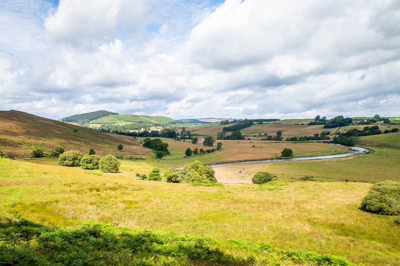
We’d parked just outside Rothbury, alongside the River Coquet, which meant the first few hundred metres – straight out of the car park – were going to be some of steepest on the route and I can’t say I was looking forward to it. As so often is the case, it wasn’t nearly as bad as I’d thought it would be and we were soon able to enjoy the gorgeous panorama across the valley of the meandering River Coquet towards Hepple (featured image at the top of the page), heading directly for the Impromptu Cycling Cafe at Elsdon, always a favourite and which, at only ten miles, would be an early stop by our normal standards.
We kept the pace relaxed over the gentler hills along the river valley saving ourselves for the long pull up Billsmoor where we were passed half-way up by a couple of guys who, by the time we arrived in Elsdon, were comfortably installed outside the cafe. As usual, it was an oasis of tranquility where the first things to catch our attention were the fluttering Union Jack, the sparrows flocking round a bird-feeder and the bush (behind Diane in the picture) swarming and buzzing loudly with bees and other insects.

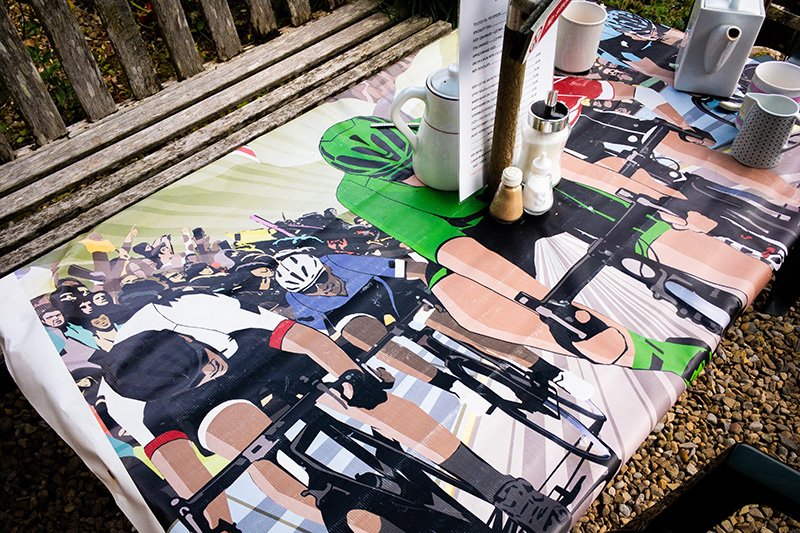
The Impromptu Cafe is a proper cycling cafe, where even the tablecloths have a cycling theme and where, at the time of writing, a pot of coffee (effectively 2 large mugs-worth) cost us £1.50. Everything was so pleasant and laid back that it took considerable willpower to hit the road again. According to the firing notices on the government web page (https://www.gov.uk/government/collections/firing-notice), there’d be no red flags to stop us. For the record, Otterburn – all 90 square miles of it – is the second-largest live-firing range in the country and has been used by the military since 1911. The Open Access Areas on the periphery of the training area are accessible all year round while the inner, Controlled Access Area, is subject to restrictions when the red flags are flying.
The landscape began to change in character as we eased ourselves over the first hill after leaving the cafe, offering a stunning panorama as the road snaked uphill into the distance. The cross-headwind was now a cross-tailwind, blowing us along nicely. We’d been told that the roads were quiet, and we weren’t to be disappointed, seeing only a couple of civilian vehicles and a solitary horse and rider – looking very much alone in what appeared to be a wilderness. As we continued to ascend, we joined good old Dere Street, constructed by the Romans between York and Edinburgh to supply the Antonine Wall and which pops up all through the north.
I’m interested in a lot of stuff – including things of a military nature – and was slightly disappointed that there was so little of it (blown up or otherwise) visible from the road. I have memories of being in various locations around Otterburn as both an army cadet and in the Territorial Army, in close proximity to loud bangs but it was a long time ago and I had absolutely no clue where I was at the time.
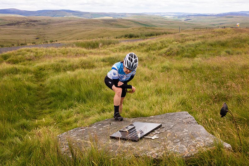
Outer Golden Pot is a military observation point where we chanced upon an unobtrusive memorial that we’d have missed if we hadn’t stopped to read an interpretation board. Directly behind the board is a marble tablet set upon a rock; inscribed upon it are the names of three Royal Marines (the accompanying picture suggests a mortar crew) who had been killed in a training accident just before the start of the Falklands War in 1982. A sculpted poppy stands at its head, waving in the wind. It’s a poignant reminder that it’s not just the enemy that kills soldiers.
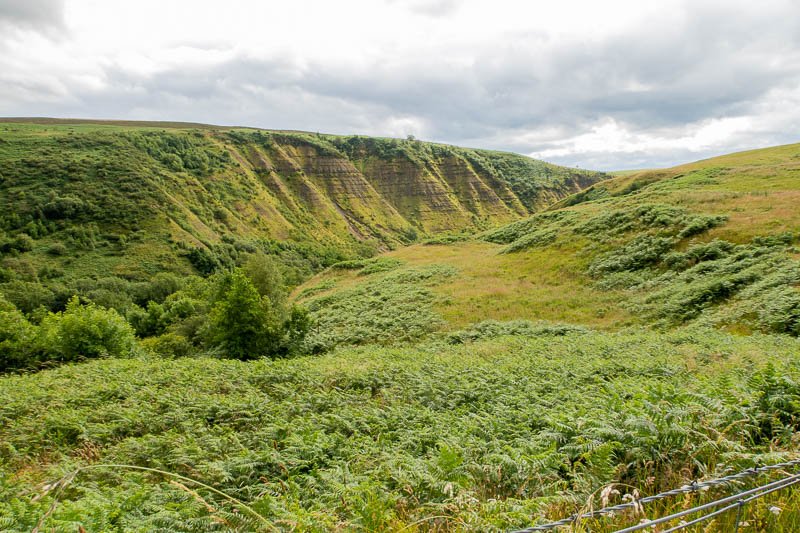
There are earthworks of several Roman marching camps in the area of which that at Chew Green could be seen clearly, on the facing slope, as we descended steeply off the moors towards the headwaters of the River Coquet. If you’re to get the maximum (speed or enjoyment) it’s important to keep your wits about you here as there are a couple of cattle grids placed mischievously on the exit from tight bends while the road itself is covered in stony debris – so be warned!
Immediately after the last grid, you hit the bottom of the descent at a bridge over a peaty stream that is the embryonic River Coquet (Coquet Head is only a short distance upstream). I don’t know why but I always love finding river sources. The three major rivers near us – Tyne, Tees and Wear – all rise within a couple of square kilometres of each other in the North Pennines. I can’t help imagining where you might end up if you were a raindrop…
At a small car park towards the top of the ensuing climb we decided to stop for a brew. As soon as we’d stopped we noticed a military truck coming down the road in the same direction. I took out the camera so that I had proof of at least one close encounter of the khaki kind but soon realised that the driver was intent on pulling into the same car park and where a large group of squaddies, suitably equipped with packs and weapons, disembarked. A soldier was posted about 30m away who had little to do other than to watch us. However surreal it might have been it didn’t stop us from an enjoying our lunch. You can only handle so much excitement though and after half an hour or so we tired of the manoeuvres and began to make preparations for a move.

Leaving the military to do their thing, the next phase of what was essentially a three-part journey for us, was a downhill thrash through Upper Coquetdale following the river to the village of Alwinton in a style that only those who know the joy of the tandem will be familiar with. The roads through Upper Coquetdale are narrower and more gnarly than on the moor, with more cattle grids than seems reasonable, one of which we hit with so much force that I was sure we’d punctured the front tyre.
On inspection there was no damage so we pushed on, past Barrowburn and Wedder Leap (a ‘wedder’ or ‘wether’ is a castrated male sheep), running ever more slowly into a broadening valley across where I could see what appeared to be an archaeological dig (the site of a medieval village on closer inspection of the map). We stopped again, shortly afterwards, on the bridge at Linbriggs (‘linn’ generally refers to a stream or waterfall; ‘brigg’ is a bridge) to take pics of the Coquet where it passes below the bridge through an attractive gorge that was immediately distinctive to me as igneous rock that turned out to be Devonian andesite of the Cheviot Volcanic Formation of which we were right on the southern edge.

Only Barrow Scar, another geological attention-grabber (Carboniferous, sedimentary and highly stratified) delayed us further and we soon found ourselves in Alwinton, a village I know quite well from fell-running races. The Rose and Thistle pub was the objective, where I was looking forward to another hardly-earned coffee. By now it was clouding over noticeably, though still warm, and we had the beer-garden to ourselves which is handy when you don’t want to feel inhibited eating your own carb-free dietary provisions.
We felt the first shuddering drops of rain as we were leaving the pub. Although we’re as well prepared for bad weather as most cyclists, I’m a fair-weather rider who braves the elements ONLY if he has no other choice. The afternoon forecast hadn’t been a good one so my priority was to close out the remaining 20 miles as quickly as possible. As soon as you cross the bridge out of Alwinton you’re on a long, stiff climb but one that offers the eventual reward of a lightning-fast route back to Rothbury. While the miles in themselves are unexceptional – particularly in dull light – I was happy enough to be moving fast enough to arrive in town just in time for another coffee – and still dry!